IMAGES TAKEN NEAR TO
Gressel Lane, BIRMINGHAM, B33 9US
Introduction
This page details the photographs taken nearby to Gressel Lane, B33 9US by members of the Geograph project.
The Geograph project started in 2005 with the aim of publishing, organising and preserving representative images for every square kilometre of Great Britain, Ireland and the Isle of Man.

There are currently over 7.5m images from over14,400 individuals and you can help contribute to the project by visiting https://www.geograph.org.uk
Image Map
Images are licensed for reuse under creativecommons.org/licenses/by-sa/2.0
Notes
- Clicking on the map will re-center to the selected point.
- The higher the marker number, the further away the image location is from the centre of the postcode.
Image Listing (14 Images Found)
Images are licensed for reuse under creativecommons.org/licenses/by-sa/2.0
Image
Details
Distance
1
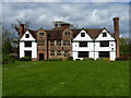
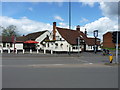
Sheldon Hall at Shard End
Grade II* listed https://www.britishlistedbuildings.co.uk/101075555-sheldon-hall-shard-end-ward#.WyTWUqdKiM9 in 1952, this fine early 16th century manor house is now a restaurant and bar. Its notable features include transomed & mullioned windows in the original central building, along with the star-shaped chimney stacks throughout.
Image: © Richard Law
Taken: 26 Apr 2018
0.01 miles
2
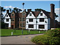
Sheldon Hall
This used to be a Manor House but now it's a bar and restaurant. A history of its descent from Tudor mansion to the present day can be found at http://www.birmingham.gov.uk/GenerateContent?CONTENT_ITEM_ID=122953&CONTENT_ITEM_TYPE=0&MENU_ID=260 .
Image: © Carl Baker
Taken: 7 Sep 2006
0.04 miles
3
Sheldon Hall
Just off Gressel Lane in Tile Cross.
Image: © Carl Baker
Taken: 7 Sep 2006
0.04 miles
4
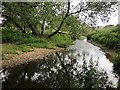
Beaches and riffles, River Cole, Kingshurst, east Birmingham
The river keeps its own course separate from the lake in Babb's Mill Recreation Ground to the north Image Houses in the distance are off Cook's Lane, B37.
Image: © Robin Stott
Taken: 15 Jun 2018
0.15 miles
5
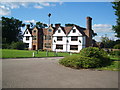
The White Hart Inn
The timber-framed heart of this Grade II listed https://www.britishlistedbuildings.co.uk/101211523-the-white-hart-public-house-shard-end-ward#.WyTUiadKiM8 public house is thought to be early 18th century, but it's been much altered over the years.
Image: © Richard Law
Taken: 26 Apr 2018
0.16 miles
6
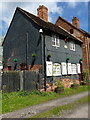
Keeper's Cottage at Shard End
A former mill-keeper's cottage, which is attached to the adjacent Image and forms part of the overall Grade II listing https://www.britishlistedbuildings.co.uk/101343453-babbs-mill-shard-end-ward#.WyTX3adKiM8 for this isolated little group.
Image: © Richard Law
Taken: 26 Apr 2018
0.18 miles
7
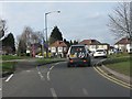
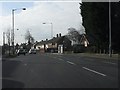
Chelmsley Road at Cooks Lane roundabout
Image: © Peter Whatley
Taken: 16 Feb 2013
0.18 miles
8
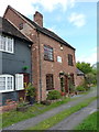
Babb's Mill at Shard End
A rather fine grade II listed https://www.britishlistedbuildings.co.uk/101343453-babbs-mill-shard-end-ward#.WyTX3adKiM8 former water millhouse, the listing being granted in 1982. The brick skin hides a timber frame, and the whole is thought to date back to the 18th century. The cottage Image partly seen to the left is also included in the listing.
Image: © Richard Law
Taken: 26 Apr 2018
0.18 miles
10

Lake, Babbs Mill Recreation Ground, Kingshurst, east Birmingham
The lake appears to be fed by a tributary of the River Cole. The Cole itself goes its own way among the vegetation on the right. The foreground might seem unprepossessing but water level was probably low, there was no litter, and behind the camera was a bank of wildflowers. A heron flopped over. The buildings on the skyline are at Fordbridge in Image
Image: © Robin Stott
Taken: 15 Jun 2018
0.20 miles