IMAGES TAKEN NEAR TO
Gressel Lane, BIRMINGHAM, B33 9UN
Introduction
This page details the photographs taken nearby to Gressel Lane, B33 9UN by members of the Geograph project.
The Geograph project started in 2005 with the aim of publishing, organising and preserving representative images for every square kilometre of Great Britain, Ireland and the Isle of Man.

There are currently over 7.5m images from over14,400 individuals and you can help contribute to the project by visiting https://www.geograph.org.uk
Image Map
Images are licensed for reuse under creativecommons.org/licenses/by-sa/2.0
Notes
- Clicking on the map will re-center to the selected point.
- The higher the marker number, the further away the image location is from the centre of the postcode.
Image Listing (23 Images Found)
Images are licensed for reuse under creativecommons.org/licenses/by-sa/2.0
Image
Details
Distance
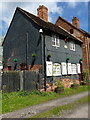
1
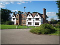
Sheldon Hall
Just off Gressel Lane in Tile Cross.
Image: © Carl Baker
Taken: 7 Sep 2006
0.10 miles
2
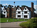
Sheldon Hall
This used to be a Manor House but now it's a bar and restaurant. A history of its descent from Tudor mansion to the present day can be found at http://www.birmingham.gov.uk/GenerateContent?CONTENT_ITEM_ID=122953&CONTENT_ITEM_TYPE=0&MENU_ID=260 .
Image: © Carl Baker
Taken: 7 Sep 2006
0.10 miles
3
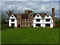
Sheldon Hall at Shard End
Grade II* listed https://www.britishlistedbuildings.co.uk/101075555-sheldon-hall-shard-end-ward#.WyTWUqdKiM9 in 1952, this fine early 16th century manor house is now a restaurant and bar. Its notable features include transomed & mullioned windows in the original central building, along with the star-shaped chimney stacks throughout.
Image: © Richard Law
Taken: 26 Apr 2018
0.12 miles
4
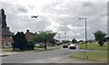
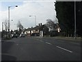
Southwest on Gressel Lane towards Kitt's Green, east Birmingham
Over Tile Cross, a huge Airbus A380 of the Emirates Airline roars up and away from Birmingham Airport. At busy times, planes seem to be taking off every couple of minutes. Noisy. https://en.wikipedia.org/wiki/Airbus_A380
Image: © Robin Stott
Taken: 15 Jun 2018
0.12 miles
5
Keeper's Cottage at Shard End
A former mill-keeper's cottage, which is attached to the adjacent Image and forms part of the overall Grade II listing https://www.britishlistedbuildings.co.uk/101343453-babbs-mill-shard-end-ward#.WyTX3adKiM8 for this isolated little group.
Image: © Richard Law
Taken: 26 Apr 2018
0.17 miles
6
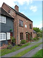
Babb's Mill at Shard End
A rather fine grade II listed https://www.britishlistedbuildings.co.uk/101343453-babbs-mill-shard-end-ward#.WyTX3adKiM8 former water millhouse, the listing being granted in 1982. The brick skin hides a timber frame, and the whole is thought to date back to the 18th century. The cottage Image partly seen to the left is also included in the listing.
Image: © Richard Law
Taken: 26 Apr 2018
0.18 miles
7
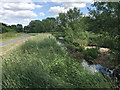
River Cole above Babb?s Mill, Kingshurst, east Birmingham
Shared footpaths and cycleways run for miles through public open spaces in the Cole valley.
Image: © Robin Stott
Taken: 21 Jun 2018
0.20 miles
8
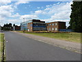
The International School and Community College, East Birmingham
Located on the site of the former Byng Kenrick Central School, which was built in 1974 as a co-educational comprehensive, and named in honour of a former local politician and Lord Mayor of Birmingham in the early 20th century.
Image: © Richard Law
Taken: 29 Jul 2014
0.20 miles
10

Cole Valley Route meets Leycroft Avenue, Tile Cross, east Birmingham
National Cycle Network Route 53. Leycroft Avenue gives access to an establishment called the International School Image
Image: © Robin Stott
Taken: 21 Jun 2018
0.22 miles