IMAGES TAKEN NEAR TO
Leycroft Avenue, BIRMINGHAM, B33 9UG
Introduction
This page details the photographs taken nearby to Leycroft Avenue, B33 9UG by members of the Geograph project.
The Geograph project started in 2005 with the aim of publishing, organising and preserving representative images for every square kilometre of Great Britain, Ireland and the Isle of Man.

There are currently over 7.5m images from over14,400 individuals and you can help contribute to the project by visiting https://www.geograph.org.uk
Image Map
Images are licensed for reuse under creativecommons.org/licenses/by-sa/2.0
Notes
- Clicking on the map will re-center to the selected point.
- The higher the marker number, the further away the image location is from the centre of the postcode.
Image Listing (27 Images Found)
Images are licensed for reuse under creativecommons.org/licenses/by-sa/2.0
Image
Details
Distance
1
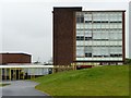
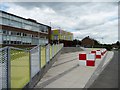
Old meets new at the International School
The covered walkways were built in 2012, to link the school's 1950s buildings.
Image: © Christine Johnstone
Taken: 13 Jul 2012
0.07 miles
2

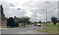
Cole Valley Route meets Leycroft Avenue, Tile Cross, east Birmingham
National Cycle Network Route 53. Leycroft Avenue gives access to an establishment called the International School Image
Image: © Robin Stott
Taken: 21 Jun 2018
0.07 miles
3
Southwest on Gressel Lane towards Kitt's Green, east Birmingham
Over Tile Cross, a huge Airbus A380 of the Emirates Airline roars up and away from Birmingham Airport. At busy times, planes seem to be taking off every couple of minutes. Noisy. https://en.wikipedia.org/wiki/Airbus_A380
Image: © Robin Stott
Taken: 15 Jun 2018
0.08 miles
4
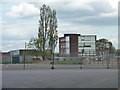
Classroom block, the International School
This was built in the mid 1950s as the form block for Byng Kenrick Girls' Grammar School.
Image: © Christine Johnstone
Taken: 16 May 2012
0.08 miles
5
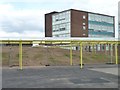
Covered ways at the International School
Created from three separate but nearby schools, footpaths with roofs are a necessity.
Image: © Christine Johnstone
Taken: 16 May 2012
0.11 miles
6
Entrance to the International School, Gressel Lane
A local comprehensive school, on the site of two 1960s grammar schools and bi-lateral technical school. This used to be the entrance to Central Boys' Grammar School.
Image: © Christine Johnstone
Taken: 16 May 2012
0.13 miles
7

An A380 Airbus has flown over the River Cole near Tile Cross, east Birmingham
It's noisier than other passenger jets and, because it's twice the size, appears to be flying very slowly. The river is clean, supporting abundant plant life. Viewed from the footbridge north of Leycroft Avenue.
Image: © Robin Stott
Taken: 21 Jun 2018
0.14 miles
8

Detail of rowan tree in grounds of Sheldon Hall School
The school has since been demolished and houses built on the site. I do not know if the tree survives.
Image: © A J Paxton
Taken: 26 Sep 2015
0.16 miles
9
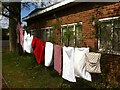
Former school building, Sheldon Hall Avenue
Rear of building, with property guardian washing, during its last phase as slum housing 2013 to 2017, when it was demolished and houses built on the site.
Image: © A J Paxton
Taken: 18 Apr 2014
0.16 miles
10
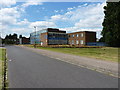
The International School and Community College, East Birmingham
Located on the site of the former Byng Kenrick Central School, which was built in 1974 as a co-educational comprehensive, and named in honour of a former local politician and Lord Mayor of Birmingham in the early 20th century.
Image: © Richard Law
Taken: 29 Jul 2014
0.16 miles