IMAGES TAKEN NEAR TO
Gressel Lane, BIRMINGHAM, B33 9UE
Introduction
This page details the photographs taken nearby to Gressel Lane, B33 9UE by members of the Geograph project.
The Geograph project started in 2005 with the aim of publishing, organising and preserving representative images for every square kilometre of Great Britain, Ireland and the Isle of Man.

There are currently over 7.5m images from over14,400 individuals and you can help contribute to the project by visiting https://www.geograph.org.uk
Image Map (Loading...)


Getting Data...Please wait
Leaflet Map data © OpenStreetMap
Images are licensed for reuse under creativecommons.org/licenses/by-sa/2.0
Notes
- Clicking on the map will re-center to the selected point.
- The higher the marker number, the further away the image location is from the centre of the postcode.
Image Listing (53 Images Found)
Images are licensed for reuse under creativecommons.org/licenses/by-sa/2.0
Image
Details
Distance
1
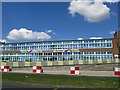
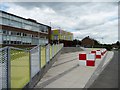
The International School, Gressel Lane, Birmingham
Image: © Ann Causer
Taken: Unknown
0.01 miles
2
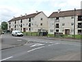
Flats in Gressel Lane
The road sign is mis-spelt - it is Gressel, not Gressell.
Image: © Christine Johnstone
Taken: 16 May 2012
0.05 miles
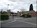
3
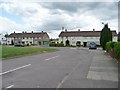
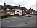
Houses in Gressel Lane
Set back from the road around a square of grass.
Image: © Christine Johnstone
Taken: 16 May 2012
0.06 miles
4
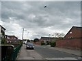
Kyngsford Road, Tile Cross
About 2 kilometres from the end of the runway at Birmingham Airport, and directly in line with it.
Image: © Christine Johnstone
Taken: 16 May 2012
0.07 miles
5
Entrance to the International School, Gressel Lane
A local comprehensive school, on the site of two 1960s grammar schools and bi-lateral technical school. This used to be the entrance to Central Boys' Grammar School.
Image: © Christine Johnstone
Taken: 16 May 2012
0.07 miles
6
Bungalows in Waterford Place
Built in the last 20 years, on the west side of Kyngsford Road.
Image: © Christine Johnstone
Taken: 16 May 2012
0.07 miles
7
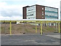
Covered ways at the International School
Created from three separate but nearby schools, footpaths with roofs are a necessity.
Image: © Christine Johnstone
Taken: 16 May 2012
0.08 miles
8
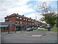
East Meadway shops, Tile Cross
With a fine view of the cruciform Catholic church through the trees.
Image: © Christine Johnstone
Taken: 16 May 2012
0.10 miles
9
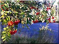
Detail of rowan tree in grounds of Sheldon Hall School
The school has since been demolished and houses built on the site. I do not know if the tree survives.
Image: © A J Paxton
Taken: 26 Sep 2015
0.10 miles
10
Former council houses, Gressel Lane
The one in the middle has definitely been bought.
Image: © Christine Johnstone
Taken: 16 May 2012
0.11 miles