IMAGES TAKEN NEAR TO
South Roundhay, BIRMINGHAM, B33 9QA
Introduction
This page details the photographs taken nearby to South Roundhay, B33 9QA by members of the Geograph project.
The Geograph project started in 2005 with the aim of publishing, organising and preserving representative images for every square kilometre of Great Britain, Ireland and the Isle of Man.

There are currently over 7.5m images from over14,400 individuals and you can help contribute to the project by visiting https://www.geograph.org.uk
Image Map
Images are licensed for reuse under creativecommons.org/licenses/by-sa/2.0
Notes
- Clicking on the map will re-center to the selected point.
- The higher the marker number, the further away the image location is from the centre of the postcode.
Image Listing (8 Images Found)
Images are licensed for reuse under creativecommons.org/licenses/by-sa/2.0
Image
Details
Distance
1
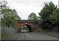
Railway bridge across Crossfield Road
Image: © Steve Fareham
Taken: 29 May 2012
0.14 miles
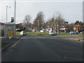
2
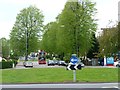
Looking west along Kitt's Green Road
Two roundabouts and two no. 14 buses.
Image: © Christine Johnstone
Taken: 16 May 2012
0.18 miles
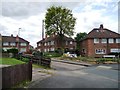
3

Lea Hall
Taken at the junction of Lea Hall Road and The Lea, one part of a vast area of mainly pre-war local authority housing. The area lies under the Birmingham Airport flight path. The railway running behind the house is the Birmingham - Coventry line, just west of Lea Hall station.
Image: © Stephen McKay
Taken: 1 Mar 2006
0.18 miles
4
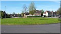
Roundabout at Lea Hall
This large roundabout controls the traffic flow to and from this large housing estate at Lea Hall.
Image: © Peter Mackenzie
Taken: 18 Apr 2017
0.18 miles
5
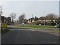
Kitts Green Road - Cole Green Lane roundabout
Image: © Peter Whatley
Taken: 16 Feb 2013
0.18 miles
6
Kitts Green Road - Crossfield Road roundabout
Image: © Peter Whatley
Taken: 16 Feb 2013
0.19 miles
7
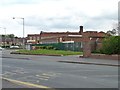
Royal Mail sorting office, Kitt's Green
On the roundabout, at 120 Kitt's Green Road.
Image: © Christine Johnstone
Taken: 16 May 2012
0.23 miles
8
Dewhurst Croft
On the west side of Kitt's Green Road.
Image: © Christine Johnstone
Taken: 16 May 2012
0.24 miles