IMAGES TAKEN NEAR TO
Scout Close, BIRMINGHAM, B33 0YW
Introduction
This page details the photographs taken nearby to Scout Close, B33 0YW by members of the Geograph project.
The Geograph project started in 2005 with the aim of publishing, organising and preserving representative images for every square kilometre of Great Britain, Ireland and the Isle of Man.

There are currently over 7.5m images from over14,400 individuals and you can help contribute to the project by visiting https://www.geograph.org.uk
Image Map
Images are licensed for reuse under creativecommons.org/licenses/by-sa/2.0
Notes
- Clicking on the map will re-center to the selected point.
- The higher the marker number, the further away the image location is from the centre of the postcode.
Image Listing (31 Images Found)
Images are licensed for reuse under creativecommons.org/licenses/by-sa/2.0
Image
Details
Distance
1
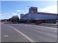
BJ's Bingo, Kitt's Green
This new bingo hall is located pretty much at the junction of Meadway with St Giles Road.
Image: © Richard Law
Taken: 16 Mar 2020
0.14 miles
2
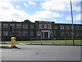
Empty office unit
This empty office unit is at the corner of Mackadown Lane and Meadway. It would be good to see it put to some good use.
Image: © Angella Streluk
Taken: 29 Aug 2005
0.14 miles

4
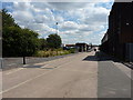
Bannerley Road, Garretts Green
One of several roads running through the extensive Garretts Green industrial estate.
Image: © Richard Law
Taken: 29 Jul 2014
0.18 miles
5
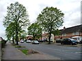
Kitt's Green Road
So many of Birmingham's suburbs benefit from tree-lined roads like this.
Image: © Christine Johnstone
Taken: 16 May 2012
0.19 miles
6
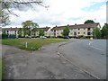
Flats on Mackadown Lane
The road junction is at the 94 metre spot height.
Image: © Christine Johnstone
Taken: 16 May 2012
0.21 miles
7
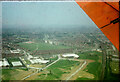
Garrets Green Lane from the air
This photo was taken from a BEA Vickers Viscount that had just taken of from Elmdon in 1963. Garrets Green Lane runs across the middle of the image with three rows of terraced houses. In the foreground are Granby Avenue and Bannerley Rd which are now part of a large industrial estate. The photo was taken while the plane was almost directly above the mainline railway (visible in the bottom right corner) from Coventry to Birmingham.
Image: © Nigel Mykura
Taken: 11 Jul 1963
0.21 miles
8
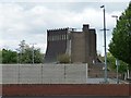
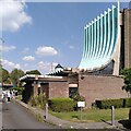
Our Lady Help of Christians Catholic Church
Seen across a car park from Mackadown Lane. Built 1966-67 and Grade 2 listed.
Image: © Christine Johnstone
Taken: 16 May 2012
0.21 miles
9
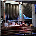
Our Lady Help of Christians, Kitts Green: interior looking towards the south transept
This view of the 1967 Catholic church by Richard Gilbert Scott shows the sanctuary with sacristy behind, underneath the high timber-framed crossing that is supported by curving vaults of reinforced concrete. The clerestory glass is by John Chrestien.
Image: © A J Paxton
Taken: 9 Sep 2023
0.21 miles
10
A Brutalist Pilgrimage
Admirers of Modernist architecture have come to see Our Lady Help of Christians, a Catholic church in Kitts Green, Birmingham, that was completed in 1967 to designs by Richard Gilbert Scott, of the famous Scott dynasty of architects. The tour was led by members of Brutiful Birmingham, which defends and promotes the city's much-maligned Modernist and Brutalist architecture. On Brutiful Birmingham see Joe Holyoak at Building Design https://www.bdonline.co.uk/briefing/review-birmingham-the-brutiful-years/5119945.article .
Image: © A J Paxton
Taken: 9 Sep 2023
0.22 miles