IMAGES TAKEN NEAR TO
Feltham Close, BIRMINGHAM, B33 0XR
Introduction
This page details the photographs taken nearby to Feltham Close, B33 0XR by members of the Geograph project.
The Geograph project started in 2005 with the aim of publishing, organising and preserving representative images for every square kilometre of Great Britain, Ireland and the Isle of Man.

There are currently over 7.5m images from over14,400 individuals and you can help contribute to the project by visiting https://www.geograph.org.uk
Image Map
Images are licensed for reuse under creativecommons.org/licenses/by-sa/2.0
Notes
- Clicking on the map will re-center to the selected point.
- The higher the marker number, the further away the image location is from the centre of the postcode.
Image Listing (22 Images Found)
Images are licensed for reuse under creativecommons.org/licenses/by-sa/2.0
Image
Details
Distance

2
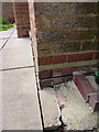
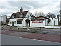
OS benchmark - Tile Cross, 81 Bell Lane
An OS cutmark at the side of no 81 Bell Lane; originally levelled in 1965 at 88.771m above Ordnance Datum Newlyn.
Image: © Richard Law
Taken: 6 May 2014
0.08 miles
3
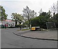
The junction of The Radleys with Bell Lane
Image: © Steve Fareham
Taken: 18 May 2012
0.11 miles
5
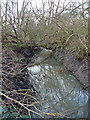
Tributary of the Hatchford Brook
A rather overgrown & neglected waterway, which drains out of housing at Lyndon Green, joins the Hatchford Brook just downstream of here, and then runs past Marston Green to join the River Cole.
Image: © Richard Law
Taken: 16 Jan 2014
0.15 miles
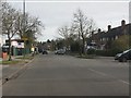
6
The Ginger Tree restaurant
Formerly this was a pub Image and it must have fairly recently changed use, as the old sign still stands in the carpark as at Jan 2014.
Image: © Richard Law
Taken: 16 Jan 2014
0.16 miles
7
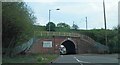
Railway bridge over The Radleys
Carrying The West Coast main line.
Image: © Steve Fareham
Taken: 18 May 2012
0.16 miles
8
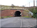
The Radleys railway bridge
The West Coast Main Line between Birmingham International and New Street crosses The Radleys at this substantial bridge. It's too narrow for two cars to pass, so a give-way system is operated.
Image: © Richard Law
Taken: 16 Jan 2014
0.16 miles
9
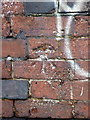
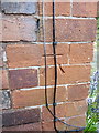
OS benchmark - Marston Green, The Radleys railway bridge
An OS cutmark in the brick buttress of the bridge carrying the West Coast Main Line over The Radleys; originally levelled at 89.57m above Ordnance Datum Newlyn.
Image: © Richard Law
Taken: 16 Jan 2014
0.16 miles
10
OS benchmark - Marston Green, no 111 Tile Cross Road
An OS cutmark at the side of no 111 Tile Cross Road; originally levelled in 1965 at 95.205m above Ordnance Datum Newlyn.
Image: © Richard Law
Taken: 6 May 2014
0.16 miles