IMAGES TAKEN NEAR TO
Hollyfaste Road, BIRMINGHAM, B33 0UU
Introduction
This page details the photographs taken nearby to Hollyfaste Road, B33 0UU by members of the Geograph project.
The Geograph project started in 2005 with the aim of publishing, organising and preserving representative images for every square kilometre of Great Britain, Ireland and the Isle of Man.

There are currently over 7.5m images from over14,400 individuals and you can help contribute to the project by visiting https://www.geograph.org.uk
Image Map
Images are licensed for reuse under creativecommons.org/licenses/by-sa/2.0
Notes
- Clicking on the map will re-center to the selected point.
- The higher the marker number, the further away the image location is from the centre of the postcode.
Image Listing (11 Images Found)
Images are licensed for reuse under creativecommons.org/licenses/by-sa/2.0
Image
Details
Distance
1
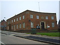
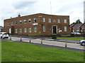
Garretts Green Lane Police Station.
Viewed from Hengham Road.
Image: © Carl Baker
Taken: 12 Sep 2006
0.13 miles
2
Hengham Road Billingsley Road Junction Garretts Green
Image: © Roy Hughes
Taken: 7 Mar 2016
0.16 miles
3
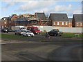
New construction at Garretts Green Lane roundabout
Image: © Peter Whatley
Taken: 7 Dec 2011
0.16 miles
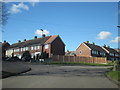
4
Sheldon Police Station
The nick appears to have had a change of name (and a new sign fixed to the wall) since Image was taken 8 years ago.
Image: © Richard Law
Taken: 4 Jul 2014
0.16 miles
5
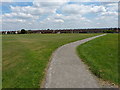
Path across Kents Moat Recreation Ground
A large area of open grassland in the middle of the Kitts Green - Lea Hall - Garretts Green housing estates, and named after the nearby Image medieval relic.
Image: © Richard Law
Taken: 29 Jul 2014
0.17 miles
6
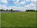
Kents Moat Rec
A small play area for the younger children and a fenced basketball court on the western side of the Kents Moat Recreation Ground.
Image: © Richard Law
Taken: 29 Jul 2014
0.18 miles
7

East Birmingham Campus
This College used to be call Garretts Green College.
Image: © Carl Baker
Taken: 12 Sep 2006
0.19 miles
9
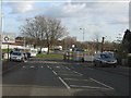
Garretts Green roundabout
A 7-way roundabout in the middle of the suburb.
Image: © Richard Law
Taken: 4 Jul 2014
0.19 miles
10
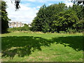
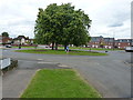
Kents Moat
Or, more properly, Kempes Moat. This is all that remains of the site of a medieval manor house in the middle of the 1930s Garretts Green housing estate.
It represents the location of a settlement occupied between the 12th and 15th centuries, apparently in some style and opulence at times, and last owned by John & Marion Kemp who lived here in the 15th century. Although no water remains in the moat, its size and shape can be made out quite clearly on the ground as a ditch roughly 15-20 feet across, and several feet deep, with trees now growing in it. The flats in the background lie within the moated enclosure, and were built in the 1960s (a time when precious little regard was paid to many historic and ancient sites, and the planning laws were rather less stringent than they are these days.)
Image: © Richard Law
Taken: 29 Jul 2014
0.20 miles