1
View along St Giles Road, Kitt's Green
Image: © Richard Law
Taken: 16 Mar 2020
0.01 miles
2
Convenience store in Kitts Green
At the junction of Shirestone Road with St Giles Road
Image: © Richard Law
Taken: 29 Jul 2014
0.06 miles
3
Terraced houses, east side of Mackadown Lane
At the junction with Richford Grove.
Image: © Christine Johnstone
Taken: 16 May 2012
0.06 miles
4
Flats on Mackadown Lane
The road junction is at the 94 metre spot height.
Image: © Christine Johnstone
Taken: 16 May 2012
0.11 miles
5
Fortnum Close, off Mackadown Lane
Characterised by a strong smell of baking, from the Premier Foods' bakery on Granby Avenue in Garrett's Green.
Image: © Christine Johnstone
Taken: 16 May 2012
0.11 miles
6
Mackadown Sports and Social Club
Their sports field is further south along Mackadown Lane.
Image: © Christine Johnstone
Taken: 16 May 2012
0.12 miles
7
Emmanuel Christian Fellowship church in Tile Cross
Situated on Shirestone Road in Tile Cross.
Image: © Richard Law
Taken: 29 Jul 2014
0.13 miles
8
Entrance to Central Business Park, Mackadown Lane
Home to Rotadex and other companies.
Image: © Christine Johnstone
Taken: 16 May 2012
0.14 miles
9
Marston Green, Birmingham
Taken on final to Birmingham Airport.
Image: © Richard Cooke
Taken: 30 Sep 2014
0.16 miles
10
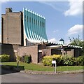
Our Lady Help of Christians with Baptistery, Kitts Green
This is a view of the church from the southeast (liturgically north), showing one of its sweeps of zigzag copper-coated concrete roofing and the bell-shaped lantern of the baptistery. The architect, Richard Gilbert Scott, achieved astonishing results on a tight budget and at a time of experimentation and uncertainty - but also opportunity - in Catholic church design following the Second Vatican Council (1962-65) and its reforms. The building is Grade II* listed - see the listing at the Historic England site https://historicengland.org.uk/listing/the-list/list-entry/1245546 .
Image: © A J Paxton
Taken: 9 Sep 2023
0.17 miles


