IMAGES TAKEN NEAR TO
East Meadway, BIRMINGHAM, B33 0EW
Introduction
This page details the photographs taken nearby to East Meadway, B33 0EW by members of the Geograph project.
The Geograph project started in 2005 with the aim of publishing, organising and preserving representative images for every square kilometre of Great Britain, Ireland and the Isle of Man.

There are currently over 7.5m images from over14,400 individuals and you can help contribute to the project by visiting https://www.geograph.org.uk
Image Map
Images are licensed for reuse under creativecommons.org/licenses/by-sa/2.0
Notes
- Clicking on the map will re-center to the selected point.
- The higher the marker number, the further away the image location is from the centre of the postcode.
Image Listing (25 Images Found)
Images are licensed for reuse under creativecommons.org/licenses/by-sa/2.0
Image
Details
Distance
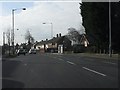
2
November morning on Geraldsfield Road
Bonjour tristesse! The green on Geraldsfield Road is part of a much larger band of public open space than extends in a U shape, crossing East Meadway, which runs across the foreground of the picture. Behind the photographer it extends around Sheldon Hall Avenue, in front along Geraldsfield Road and Shirestone Road. These 1950s council estates were built to a very low density by 21st century British standards, with large expanses of green, though there is also a some high rise housing on Shirestone Road.
Image: © A J Paxton
Taken: 4 Nov 2015
0.12 miles
3
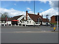
The White Hart Inn
The timber-framed heart of this Grade II listed https://www.britishlistedbuildings.co.uk/101211523-the-white-hart-public-house-shard-end-ward#.WyTUiadKiM8 public house is thought to be early 18th century, but it's been much altered over the years.
Image: © Richard Law
Taken: 26 Apr 2018
0.14 miles
4
Sheldon Hall Avenue
Viewed from former school.
Image: © A J Paxton
Taken: 18 Apr 2014
0.16 miles
5
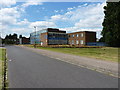
The International School and Community College, East Birmingham
Located on the site of the former Byng Kenrick Central School, which was built in 1974 as a co-educational comprehensive, and named in honour of a former local politician and Lord Mayor of Birmingham in the early 20th century.
Image: © Richard Law
Taken: 29 Jul 2014
0.16 miles
6
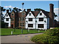
Sheldon Hall
This used to be a Manor House but now it's a bar and restaurant. A history of its descent from Tudor mansion to the present day can be found at http://www.birmingham.gov.uk/GenerateContent?CONTENT_ITEM_ID=122953&CONTENT_ITEM_TYPE=0&MENU_ID=260 .
Image: © Carl Baker
Taken: 7 Sep 2006
0.16 miles
7
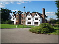
Sheldon Hall
Just off Gressel Lane in Tile Cross.
Image: © Carl Baker
Taken: 7 Sep 2006
0.16 miles
8
Sheldon Hall Avenue
Sheldon Hall Avenue looking NE towards Sheldon Hall, photo taken from the former Sheldon Hall School (formerly Byng Kenrick Central School).
Image: © A J Paxton
Taken: 21 Mar 2014
0.17 miles
9
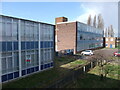
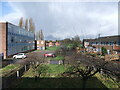
Former school, Sheldon Hall Avenue
The school buildings appear to date from the late 1950s. They were part of a larger complex of school buildings on a nearby, but not adjoining, site on Gressel Lane. Two schools used the sites, the Wilfred Martineau School, and the Bing Kenrick Central School, which was itself an merger of two earlier schools, Bing Kenrick Girls' Grammar School and Central School (originally a boys's school). In 2001 the two schools became The International School and Community College. The Sheldon Hall Avenue site was later closed and between 2013 and 2017 provided slum housing for property guardians. The buildings were then demolished and houses built on the site. The larger Gressel Lane site (not visible in this photo) continues to be used as a school.
Image: © A J Paxton
Taken: 21 Mar 2014
0.17 miles
10
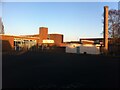
Former school, Sheldon Hall Avenue
Viewed from the playground behind the school. Formerly part of the International School and Community College, the buildings were lived in by property guardians from 2013 to 2017, then demolished, with houses built on the site.
Image: © A J Paxton
Taken: 23 Mar 2014
0.17 miles