IMAGES TAKEN NEAR TO
Knowles Way, BIRMINGHAM, B31 5LB
Introduction
This page details the photographs taken nearby to Knowles Way, B31 5LB by members of the Geograph project.
The Geograph project started in 2005 with the aim of publishing, organising and preserving representative images for every square kilometre of Great Britain, Ireland and the Isle of Man.

There are currently over 7.5m images from over14,400 individuals and you can help contribute to the project by visiting https://www.geograph.org.uk
Image Map
Images are licensed for reuse under creativecommons.org/licenses/by-sa/2.0
Notes
- Clicking on the map will re-center to the selected point.
- The higher the marker number, the further away the image location is from the centre of the postcode.
Image Listing (14 Images Found)
Images are licensed for reuse under creativecommons.org/licenses/by-sa/2.0
Image
Details
Distance
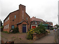
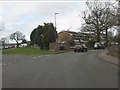
2
Houses on Frankley Beeches Road
Photographed from Elan Road.
Image: © Peter Whatley
Taken: 10 Mar 2012
0.08 miles
4
The Dingle Public House.
Standing at the junction of Frankley Beeches Road and Egghill Lane.
Image: © Roy Hughes
Taken: 3 Feb 2009
0.10 miles
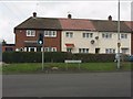
5
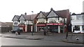
Parade of Shops on Egghill Lane
This parade stands opposite Norrington Road. See Image
Image: © Paul Collins
Taken: 10 Nov 2016
0.11 miles
6
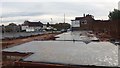
New Housing on Egghill Lane
This view shows the northern edge of a major area of residential redevelopment comprising regeneration of the Egghill Estate and including about 500 or 600 new homes. The area is bounded by Frogmill
Road to the west, Tessall Lane to the south and east and Egghill
Lane to the north. The junction of Norrington Road and Egghill Lane is visible across the foundation slabs.
Image: © Paul Collins
Taken: 10 Nov 2016
0.11 miles
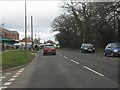
7
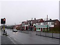
Egghill Lane
This part of Egghill Lane with the traffic lights and pedestrian crossing is in the very south of the square. The row of shops is in SP0078.
Image: © Nigel Mykura
Taken: 19 Feb 2011
0.14 miles
8
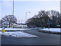
Egghill Lane, Frankley Beeches Island
The island at the road junction opposite the Dingle Pub.
Image: © Roy Hughes
Taken: 3 Feb 2009
0.17 miles
9
Elan Road from Tessall Lane
Tessall Lane continues ahead as the side road on the left and again on the through route to Rubery, but the through route has been severed at the junction with Frankley Beeches Road.
Image: © Peter Whatley
Taken: 10 Mar 2012
0.18 miles
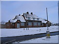
10
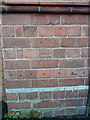
OS benchmark - Northfield, lodge at the (former) Hollymoor hospital site
Levelled in 1980 at 196.250m above Ordnance Datum Newlyn, this well-preserved benchmark sits on the lodge to the former mental hospital site.
Image: © Richard Law
Taken: 20 Jan 2020
0.18 miles