IMAGES TAKEN NEAR TO
Tessall Lane, BIRMINGHAM, B31 5EF
Introduction
This page details the photographs taken nearby to Tessall Lane, B31 5EF by members of the Geograph project.
The Geograph project started in 2005 with the aim of publishing, organising and preserving representative images for every square kilometre of Great Britain, Ireland and the Isle of Man.

There are currently over 7.5m images from over14,400 individuals and you can help contribute to the project by visiting https://www.geograph.org.uk
Image Map
Images are licensed for reuse under creativecommons.org/licenses/by-sa/2.0
Notes
- Clicking on the map will re-center to the selected point.
- The higher the marker number, the further away the image location is from the centre of the postcode.
Image Listing (16 Images Found)
Images are licensed for reuse under creativecommons.org/licenses/by-sa/2.0
Image
Details
Distance
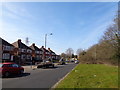
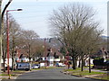
1
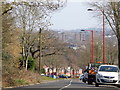
Looking down Tessall Lane, Longbridge
The first bloc of flats in the distance are at Turves Green.
Image: © Jeff Gogarty
Taken: 14 Mar 2016
0.02 miles
3
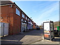
Shops on the top of Tessall Lane, Longbridge
Image: © Jeff Gogarty
Taken: 14 Mar 2016
0.10 miles
4
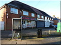
Local shops and businesses just off Tessall Lane
Image: © Richard Law
Taken: 20 Jan 2020
0.10 miles
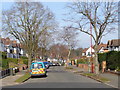
5
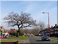
Tree on Tessall Lane, Longbridge, Birmingham
Image: © Jeff Gogarty
Taken: 14 Mar 2016
0.11 miles
6
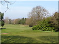
North Worcestershire Golf Club, Longbridge, Birmingham
This club is closing at the end of March 2016 to be replaced by housing.
Image: © Jeff Gogarty
Taken: 14 Mar 2016
0.13 miles
7
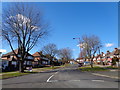
Tessall Lane, Northfield (towards the golf club)
Taken from the roundabout at the junction of Tessall Lane and Hanging Lane
Image: © Jeff Gogarty
Taken: 7 Mar 2016
0.13 miles
8
The top of Tessall Lane, Longbridge, Birmingham
Image: © Jeff Gogarty
Taken: 14 Mar 2016
0.13 miles
10
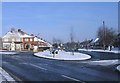
Tessall Lane, Hanging Lane Junction, Northfield.
Image: © Roy Hughes
Taken: 4 Feb 2009
0.17 miles