IMAGES TAKEN NEAR TO
Tunnel Lane, BIRMINGHAM, B30 3JN
Introduction
This page details the photographs taken nearby to Tunnel Lane, B30 3JN by members of the Geograph project.
The Geograph project started in 2005 with the aim of publishing, organising and preserving representative images for every square kilometre of Great Britain, Ireland and the Isle of Man.

There are currently over 7.5m images from over14,400 individuals and you can help contribute to the project by visiting https://www.geograph.org.uk
Image Map
Images are licensed for reuse under creativecommons.org/licenses/by-sa/2.0
Notes
- Clicking on the map will re-center to the selected point.
- The higher the marker number, the further away the image location is from the centre of the postcode.
Image Listing (76 Images Found)
Images are licensed for reuse under creativecommons.org/licenses/by-sa/2.0
Image
Details
Distance
1
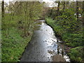
River Rea Approaching Lifford From Lifford Lane.
Image: © Roy Hughes
Taken: 7 Apr 2009
0.05 miles
2
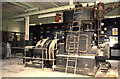
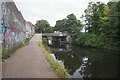
Steam engine, J & E Sturge, Lifford Lane
Belliss & Morcom engine No. 10642 of 1951 driving an alternator. Believed removed for reuse. Sturge were chemical manufacturers. I took no exteriors of the works but did stop to photograph the nearby guillotine stop lock on the Stratford Canal.
Image: © Chris Allen
Taken: 19 Nov 1988
0.07 miles
3
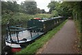
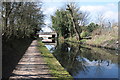
Canal boat Lady Susan, Stratford-upon-Avon Canal
Image: © Ian S
Taken: 20 Aug 2021
0.10 miles
4
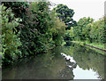
Stratford-upon-Avon Canal near King's Norton, Birmingham
This part of the canal was built in the mid 1790s, though financial problems caused delays before the canal could open as far as Kingswood Junction (with the Grand Union) in 1803. The second stage (to Stratford) did not start until 1812, and was finished by 1815. Initial plans for a wide canal (the reason for the wide bridges and tunnels) were abandoned at an early stage.
Image: © Roger D Kidd
Taken: 8 Sep 2008
0.11 miles
5
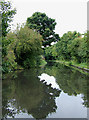
Stratford-upon-Avon Canal near King's Norton, Birmingham
This part of the canal was built in the mid 1790s, though financial problems caused delays before the canal could open as far as Kingswood Junction (with the Grand Union) in 1803. The second stage (to Stratford) did not start until 1812, and was finished by 1815. Initial plans for a wide canal (the reason for the wide bridges and tunnels) were abandoned at an early stage.
Image: © Roger D Kidd
Taken: 8 Sep 2008
0.11 miles
6
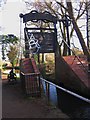
Guillotine Lock, King's Norton (East side)
One of the pair of Guillotine locks on the Stratford-on-Avon Canal at King's Norton. The locks are no longer in use but are Grade II* listed buildings. It is a pity that some thoughtless people felt they needed to spray graffiti on it.
Image: © Noisar
Taken: 8 Jan 2019
0.11 miles
7
Bridge 73 from the north
Bridge 73 on the Worcester and Birmingham Canal viewed here from the north. At this bridge the canal towpath crosses the bridge to the west bank of the canal. The bridge carries Lifford Lane.
Image: © Philip Halling
Taken: 20 Apr 2013
0.11 miles
9
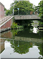
Lifford Lane Bridge in King's Norton, Birmingham
This is bridge No 73 on the Worcester and Birmingham Canal.
The Worcester and Birmingham Canal was constructed in stages between 1791 and 1815. Grain, timber and agricultural produce were carried to the Midlands. Industrial goods and coal were carried down towards Worcester, often for onward transport to Bristol. Later, salt carrying was added as a regular cargo. Pairs of donkeys were often used in preference to horses, maybe because they could easily be put onto the boats which had to be legged (or pulled by tug) through the four tunnels near Birmingham.
Image: © Roger D Kidd
Taken: 25 Aug 2010
0.12 miles
10
Worcester & Birmingham Canal at Lifford Bridge, bridge #73
Image: © Ian S
Taken: 20 Aug 2021
0.12 miles