1
Midland Bank Stirchley. Sorting code 40-11-40.
I worked for Midland Bank HSBC for 32 years and spent all but the last two in Birmingham Branches. I am photographing all the branches, or what's left of them, as they were when I joined Midland Bank in 1963. The branches all start with the sorting code 40-11.
This was the 1398 Pershore Road, Stirchley branch which was, at the time, a sub-office to Cotteridge branch. An original Guinea and Griffin logo is still visible above the door. The sorting code was 40-11-40.
Image: © Roy Hughes
Taken: 17 Dec 2008
0.02 miles
2
Pershore Road, Stirchley
Shops on Pershore Road seen from the end of Mary Vale Road.
Image: © Stephen McKay
Taken: 28 Dec 2011
0.02 miles
3
Junction of Mary Vale Road and Pershore Road (A441), Stirchley, Birmingham
Mary Vale Road is in the foreground. The shops visible in Pershore Road are, from left to right, Phull Watch Co., Caspian Pizza, Stirchley Alterations & Dressmaking, Five Star Barber Shop, Mirror Image Hair Studio, Gent's of Stirchley (Gentlemens Hairdressers), and Maggies Munchies (café). Definitely a good area to head for if you want a haircut!
Image: © P L Chadwick
Taken: 26 Aug 2014
0.02 miles
4
Warren Road, Stirchley, Birmingham
A residential road consisting of terraced housing. Unusually, on the right hand side, there are three long housing terraces set at right angles to the road. These are accessed by narrow lanes from Warren Road. The photograph was taken from Warren Road's junction with Hazelwell Road. The property on the right hand corner, as is so often the case with older roads, was clearly once business premises. Probably a shop, an off-licence or a public house. At the other end of Warren Road, it comes out on Hunts Road.
Image: © P L Chadwick
Taken: 3 Jan 2017
0.04 miles
5
Robert Oulsnam & Company, 1394-1396 Pershore Road, Stirchley, Birmingham
Located on the corner of Hunts Road and Pershore Road, this is a branch of Robert Oulsnam & Company. They are estate agents with several offices in the Birmingham area and north Worcestershire and specialise in the selling and letting of homes. This office was formerly Laing & Co. Next door is an office of David Bunn & Co, a firm of solicitors specialising in conveyancing, probate and similar areas.
Image: © P L Chadwick
Taken: 26 Aug 2014
0.05 miles
6
Terraced Houses with Benchmark, Hazelwell Road
These houses were built around the end of the 19th century and front directly onto the pavement. No. 1 Hazelwell Road (the nearest house) boasts an Ordnance Survey cut benchmark, which is just visible. Hazelwell Road was, at least until the 1880s, an undeveloped lane branching off the Pershore Road (itself originally a Roman Road at this point) to serve as access to Hazelwell Mill. The mill, on the River Rea was, according to old maps, a 'gunbarrel factory' in 1882; and in 1903 and 1937 a 'rubber goods factory'. Its site is now occupied by a trading estate.
Image: © Paul Collins
Taken: 26 Jul 2024
0.06 miles
7
Stirchley Primary School, 1459 Pershore Road
The school buildings visible were built before 1882 and were, at that time, the only buildings on the west side of this part of the Pershore Road. They also pre-date the construction of Charlotte Road behind, onto which the school now has a vehicular entrance.
Image: © Paul Collins
Taken: 26 Jul 2024
0.07 miles
8
Plymouth Road, Stirchley, Birmingham
A residential road, viewed here from its junction with Hazelwell Road. At the other end, Plymouth Road comes out on Hunts Road.
Image: © P L Chadwick
Taken: 3 Jan 2017
0.09 miles
9
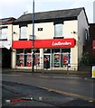
Ladbrokes, 1369 Pershore Road, Stirchley, Birmingham
Local branch of the national chain of betting shops, or turf accountants, if you prefer. At first floor level, between the two windows, is a plaque with the date 1882.
Image: © P L Chadwick
Taken: 25 Oct 2013
0.09 miles
10
Hazelwell Road, Stirchley, Birmingham
A residential road which in the far distance ends at a T-junction with Pershore Road, part of the A441. In the other direction, Hazelwell Road terminates at the entrance to a trading estate.
Image: © P L Chadwick
Taken: 3 Jan 2017
0.09 miles


