IMAGES TAKEN NEAR TO
Hazelwell Road, BIRMINGHAM, B30 2PE
Introduction
This page details the photographs taken nearby to Hazelwell Road, B30 2PE by members of the Geograph project.
The Geograph project started in 2005 with the aim of publishing, organising and preserving representative images for every square kilometre of Great Britain, Ireland and the Isle of Man.

There are currently over 7.5m images from over14,400 individuals and you can help contribute to the project by visiting https://www.geograph.org.uk
Image Map
Images are licensed for reuse under creativecommons.org/licenses/by-sa/2.0
Notes
- Clicking on the map will re-center to the selected point.
- The higher the marker number, the further away the image location is from the centre of the postcode.
Image Listing (90 Images Found)
Images are licensed for reuse under creativecommons.org/licenses/by-sa/2.0
Image
Details
Distance
1
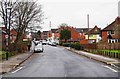
Plymouth Road, Stirchley, Birmingham
A residential road, viewed here from its junction with Hazelwell Road. At the other end, Plymouth Road comes out on Hunts Road.
Image: © P L Chadwick
Taken: 3 Jan 2017
0.02 miles
2
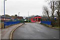
Bridge over the River Rea, Hazelwell Road, Stirchley, Birmingham
The bridge carries Hazelwell Road over the River Rea and then gives access to the Mucklow Stirchley Trading Estate, seen in the distance.
Image: © P L Chadwick
Taken: 3 Jan 2017
0.02 miles
3
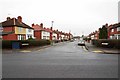
Hazelwell Road, Stirchley, Birmingham
A residential road which in the far distance ends at a T-junction with Pershore Road, part of the A441. In the other direction, Hazelwell Road terminates at the entrance to a trading estate.
Image: © P L Chadwick
Taken: 3 Jan 2017
0.02 miles
4
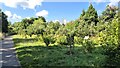
The Kingdom Forest Garden, Stirchley
This is a community garden on city council owned riverside land. It is a forest garden containing many fruit trees and bushes, herbaceous plants and various edible plants. It was established in 2017 and is developed and maintained by the charity Fruit & Nut Village who have around 40 growing spaces across the wider area.
Image: © Paul Collins
Taken: 26 Jul 2024
0.05 miles
5
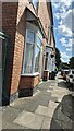
Terraced Houses with Benchmark, Hazelwell Road
These houses were built around the end of the 19th century and front directly onto the pavement. No. 1 Hazelwell Road (the nearest house) boasts an Ordnance Survey cut benchmark, which is just visible. Hazelwell Road was, at least until the 1880s, an undeveloped lane branching off the Pershore Road (itself originally a Roman Road at this point) to serve as access to Hazelwell Mill. The mill, on the River Rea was, according to old maps, a 'gunbarrel factory' in 1882; and in 1903 and 1937 a 'rubber goods factory'. Its site is now occupied by a trading estate.
Image: © Paul Collins
Taken: 26 Jul 2024
0.05 miles
6
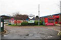
Entrance to Mucklow Stirchley Trading Estate, Hazelwell Road, Stirchley, Birmingham
The entrance to A & J Mucklow Group plc's Stirchley Trading Estate.
Image: © P L Chadwick
Taken: 3 Jan 2017
0.05 miles
7

Speedy Hire Services, Unit 1 & 2 Stirchley Trading Estate, Stirchley, Birmingham
Local branch of a national firm which hires out tools, plant, specialist equipment and provides support services. Also does sales.
Image: © P L Chadwick
Taken: 3 Jan 2017
0.06 miles
8
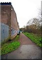
Rea Valley Cycle Route, Stirchley, Birmingham
This is a combined cycleway and footpath. It is running here past the Stirchley Trading Estate on the left.
Image: © P L Chadwick
Taken: 3 Jan 2017
0.06 miles
9
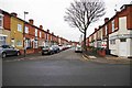
Warren Road, Stirchley, Birmingham
A residential road consisting of terraced housing. Unusually, on the right hand side, there are three long housing terraces set at right angles to the road. These are accessed by narrow lanes from Warren Road. The photograph was taken from Warren Road's junction with Hazelwell Road. The property on the right hand corner, as is so often the case with older roads, was clearly once business premises. Probably a shop, an off-licence or a public house. At the other end of Warren Road, it comes out on Hunts Road.
Image: © P L Chadwick
Taken: 3 Jan 2017
0.07 miles
10
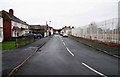
Hunts Road, Stirchley, Birmingham
What remains in this part of the road is mainly residential. The site behind the railings on the right is at present disused.
Image
Image: © P L Chadwick
Taken: 3 Jan 2017
0.07 miles