IMAGES TAKEN NEAR TO
Umberslade Road, BIRMINGHAM, B29 7SG
Introduction
This page details the photographs taken nearby to Umberslade Road, B29 7SG by members of the Geograph project.
The Geograph project started in 2005 with the aim of publishing, organising and preserving representative images for every square kilometre of Great Britain, Ireland and the Isle of Man.

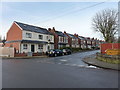
There are currently over 7.5m images from over14,400 individuals and you can help contribute to the project by visiting https://www.geograph.org.uk
Image Map
Images are licensed for reuse under creativecommons.org/licenses/by-sa/2.0
Notes
- Clicking on the map will re-center to the selected point.
- The higher the marker number, the further away the image location is from the centre of the postcode.
Image Listing (50 Images Found)
Images are licensed for reuse under creativecommons.org/licenses/by-sa/2.0
Image
Details
Distance
1
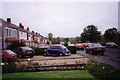
Umberslade Road in 1992
Looking south-east.
Image: © Ruth Riddle
Taken: Unknown
0.02 miles
2
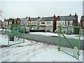
Umberslake Road, Selly Oak
Early 20th century semis viewed from the entrance of the Rathbone Garden Centre, see Image
Image: © Jonathan Billinger
Taken: 11 Jan 2010
0.02 miles
3
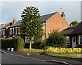
165 Umberslade road
Araucaria araucana
Image: © araucaria araucana
Taken: 16 Oct 2014
0.03 miles
4
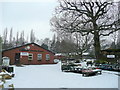
Rathbone Garden Centre
On Umberslake Road, Selly Oak, the business performs a charitable role in employing folks with learning difficulties.
Image: © Jonathan Billinger
Taken: 11 Jan 2010
0.06 miles
5
Gristhorpe Road from Ribblesdale Road, Stirchley
Turn of the 20th century housing in the Stirchley area of Birmingham.
Image: © Richard Law
Taken: 16 Dec 2019
0.08 miles
6
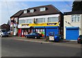
Premier Kwik Stop Convenience Store, 16 Ribblesdale Road, Stirchley, Birmingham
This store is a member of a leading group of independent convenience stores which trade under the Premier brand. The brand is owned by the wholesalers Booker Cash & Carry Ltd who provide stock and support.
Image: © P L Chadwick
Taken: 8 Apr 2015
0.17 miles
7
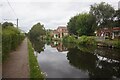
Worcester & Birmingham Canal towards bridge #77B
Image: © Ian S
Taken: 20 Aug 2021
0.18 miles
8
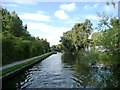
Narrows on the Worcester & Birmingham Canal
'Narrows' are places where a canal is intentionally built at its minimum width. Sometimes they are the site of a demolished bridge. More often [and I think in this case] they are points where stop planks can be dropped in across the canal, to close it. This would stop all the water draining out of a long pound if there was a breach somewhere.
Image: © Christine Johnstone
Taken: 4 Sep 2012
0.18 miles
9
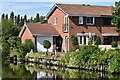
Modern house beside the Worcester and Birmingham Canal
This canalside property is in Sparrey Drive.
Image: © David Martin
Taken: 7 Aug 2022
0.18 miles
10
Umberslade Road
On the left is Morrisons supermarket.
Image: © Gerald England
Taken: 6 Jul 2024
0.19 miles