IMAGES TAKEN NEAR TO
Third Avenue, BIRMINGHAM, B29 7EX
Introduction
This page details the photographs taken nearby to Third Avenue, B29 7EX by members of the Geograph project.
The Geograph project started in 2005 with the aim of publishing, organising and preserving representative images for every square kilometre of Great Britain, Ireland and the Isle of Man.

There are currently over 7.5m images from over14,400 individuals and you can help contribute to the project by visiting https://www.geograph.org.uk
Image Map
Images are licensed for reuse under creativecommons.org/licenses/by-sa/2.0
Notes
- Clicking on the map will re-center to the selected point.
- The higher the marker number, the further away the image location is from the centre of the postcode.
Image Listing (82 Images Found)
Images are licensed for reuse under creativecommons.org/licenses/by-sa/2.0
Image
Details
Distance
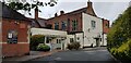
1
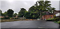
Rear of Selly Park Tavern
To the left of the view is a bowling green. The pub itself is on the extreme right and the building to the right of the oak tree is a skittle alley, also used for community purposes.
Image: © Paul Collins
Taken: 30 Jul 2021
0.04 miles
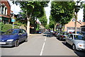
2
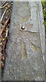
Ordnance Survey Rivet Benchmark
Rare rivet benchmark installed in a kerb stone in Second Avenue. Only 1404 of this type of benchmark were installed by OS out of over half a million total benchmarks. The pheon (broad arrow) shows it is government property and the rivet itself marks the exact coordinates and elevation. Many have been subsequently destroyed and this is the only confirmed rivet benchmark in a kerbstone in the wider Birmingham area.
It is recorded as RV0240 in the OS Benchmark Database with reference information: RIVET: RIVET KERB S SIDE SECOND AVE 0.9M N PRODN S FACE NO52 (ODN 114.769m, AGL 0.0m).
Image: © Scroff Kruddel
Taken: 4 Apr 2024
0.05 miles
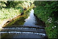
4
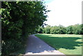
National Cycle Route 5, Cannon Hill Park
Image: © N Chadwick
Taken: 11 Jun 2011
0.05 miles
5
Rear of Selly Park Tavern
The annexe to the left of the view is a traditional skittle alley. It is also used for community purposes and as a polling station.
Image: © Paul Collins
Taken: 30 Jul 2021
0.06 miles
8
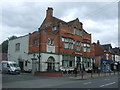
The Selly Park Tavern
An Ember Inn on Pershore Road.
Image: © JThomas
Taken: 22 Jul 2017
0.08 miles
9
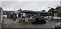
Five Star Valeting Services
This car washing centre occupies a site to the rear of the filling station.
Image: © Paul Collins
Taken: 30 Jul 2021
0.08 miles
10
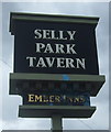
Sign for the Selly Park Tavern
An Ember Inn.
Image: © JThomas
Taken: 22 Jul 2017
0.08 miles