Ordnance Survey Rivet Benchmark
Introduction
The photograph on this page of Ordnance Survey Rivet Benchmark by Scroff Kruddel as part of the Geograph project.
The Geograph project started in 2005 with the aim of publishing, organising and preserving representative images for every square kilometre of Great Britain, Ireland and the Isle of Man.

There are currently over 7.5m images from over 14,400 individuals and you can help contribute to the project by visiting https://www.geograph.org.uk
Ordnance Survey Rivet Benchmark
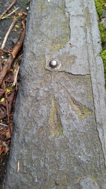
Image: © Scroff Kruddel Taken: 4 Apr 2024
Rare rivet benchmark installed in a kerb stone in Second Avenue. Only 1404 of this type of benchmark were installed by OS out of over half a million total benchmarks. The pheon (broad arrow) shows it is government property and the rivet itself marks the exact coordinates and elevation. Many have been subsequently destroyed and this is the only confirmed rivet benchmark in a kerbstone in the wider Birmingham area. It is recorded as RV0240 in the OS Benchmark Database with reference information: RIVET: RIVET KERB S SIDE SECOND AVE 0.9M N PRODN S FACE NO52 (ODN 114.769m, AGL 0.0m).
Images are licensed for reuse under creativecommons.org/licenses/by-sa/2.0
Image Location
Latitude
52.445831
Longitude
-1.912268