IMAGES TAKEN NEAR TO
Endsleigh Grove, BIRMINGHAM, B28 8NU
Introduction
This page details the photographs taken nearby to Endsleigh Grove, B28 8NU by members of the Geograph project.
The Geograph project started in 2005 with the aim of publishing, organising and preserving representative images for every square kilometre of Great Britain, Ireland and the Isle of Man.

There are currently over 7.5m images from over14,400 individuals and you can help contribute to the project by visiting https://www.geograph.org.uk
Image Map
Images are licensed for reuse under creativecommons.org/licenses/by-sa/2.0
Notes
- Clicking on the map will re-center to the selected point.
- The higher the marker number, the further away the image location is from the centre of the postcode.
Image Listing (12 Images Found)
Images are licensed for reuse under creativecommons.org/licenses/by-sa/2.0
Image
Details
Distance
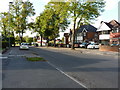
1
Sunset over Almshouses, Hall Green
The one-storey brick almshouses were designed in the Jacobean Style in the 1930's. They stand on three sides of a green; the fourth open side faces Fox Hollies Road. They stand in the School Road conservation area at junction of School Road and Fox Hollies Road.
Image: © Michael Westley
Taken: 7 Mar 2011
0.04 miles
2
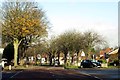
Fox Hollies Road to Acock's Green
The A4040 is the Outer Ring Road in Birmingham.
Image: © Steve Daniels
Taken: 5 Dec 2014
0.07 miles
3
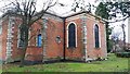
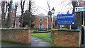
The Church of the Ascension, Hall Green
Built in 1704 in the Queen Anne style, the parish church is grade II* listed and separated from the busy Fox Hollies Road and School Road by brick boundary walls. https://en.wikipedia.org/wiki/Church_of_the_Ascension,_Hall_Green
Image: © Paul Collins
Taken: 23 Jan 2018
0.10 miles
4
The Church of the Ascension, Hall Green
Built in 1704 in the Queen Anne style, the parish church is grade II* listed and separated from the busy Fox Hollies Road and School Road by brick boundary walls. https://en.wikipedia.org/wiki/Church_of_the_Ascension,_Hall_Green
Image: © Paul Collins
Taken: 23 Jan 2018
0.11 miles
5
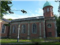
Hall Green Parish Church of the Ascension
Originally built in 1704, but extended and altered in the 1860s, this church was given a Grade II* listing https://britishlistedbuildings.co.uk/101076183-parish-church-of-the-ascension-hall-green-ward#.W9QuGNQrLGg in 1952. The architect is believed to be Sir William Wilson of Leicester, a pupil of Christopher Wren (famously of St Paul's in London) and who also carved a statue of King Edward VI at the original grammar school in Edgbaston.
Image: © Richard Law
Taken: 12 Sep 2018
0.11 miles
6
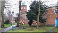
Church of the Ascension, Hall Green
Built in 1704 in the Queen Anne style, the parish church is grade II* listed and separated from the busy Fox Hollies Road and School Road by brick boundary walls. https://en.wikipedia.org/wiki/Church_of_the_Ascension,_Hall_Green
Image: © Paul Collins
Taken: 23 Jan 2018
0.12 miles
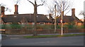
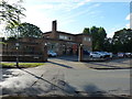
7
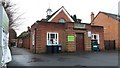
Church Hall in School Road
This building is the church hall, coffee lounge and church office for the Church of the Ascension, which stands immediately adjacent.
Image: © Paul Collins
Taken: 23 Jan 2018
0.13 miles
8
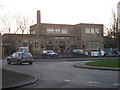
The Maggies
Public house on corner of Shirley Road and School Road, Hall Green - formerly known as 'The Magpies'.
Circa 1935, the pub is a rectilinear building inspired by the Bauhaus School. It features a roof terrace and its own bowling green and pavilion
Image: © Michael Westley
Taken: 7 Mar 2011
0.16 miles
9
The Maggies pub
Formerly known as The Three Magpies when it was Grade II listed https://britishlistedbuildings.co.uk/101245354-the-three-magpies-public-house-and-attached-walls-hall-green-ward#.W9QqW9QrLGg in 1997; the pub was built in 1935 for the Mitchell & Butlers brewery chain, and includes a remarkably well preserved set of public bar, Assembly Room, gents' Smoking Room, Outdoor Dept, toilets and the entrance hall. The listing includes the walls surrounding the rear carpark, as they feature a number of bench seats, and which adjoin the bowling green.
Image: © Richard Law
Taken: 12 Sep 2018
0.17 miles