IMAGES TAKEN NEAR TO
Coventry Road, BIRMINGHAM, B25 8AF
Introduction
This page details the photographs taken nearby to Coventry Road, B25 8AF by members of the Geograph project.
The Geograph project started in 2005 with the aim of publishing, organising and preserving representative images for every square kilometre of Great Britain, Ireland and the Isle of Man.

There are currently over 7.5m images from over14,400 individuals and you can help contribute to the project by visiting https://www.geograph.org.uk
Image Map
Images are licensed for reuse under creativecommons.org/licenses/by-sa/2.0
Notes
- Clicking on the map will re-center to the selected point.
- The higher the marker number, the further away the image location is from the centre of the postcode.
Image Listing (42 Images Found)
Images are licensed for reuse under creativecommons.org/licenses/by-sa/2.0
Image
Details
Distance
1
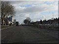
Coventry Road (A45) at Holder Road traffic lights
Image: © Peter Whatley
Taken: 7 Dec 2011
0.02 miles
2
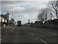
Coventry Road (A45) at Howard Road
Very reminiscent of London's North Circular Road and Great West Road, but rather freer flowing.
Image: © Peter Whatley
Taken: 7 Dec 2011
0.08 miles
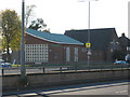
3
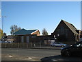
South Yardley Methodist Church
Coventry Road, near 'The Swan' island
Image: © Michael Westley
Taken: 25 Oct 2010
0.08 miles
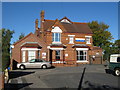
4
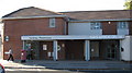
Yardley Pharmacy and Swan Medical Centre
On corner of Willard Road and Coventry Road, near Swan island
Image: © Michael Westley
Taken: 25 Oct 2010
0.09 miles
5
South Yardley Methodist Church
Corner of Coventry Road and Broadyates Road
Image: © Michael Westley
Taken: 25 Oct 2010
0.11 miles
6
Health Centre, Willard Road
In small cul-de-sac off Coventry Road, near Swan island
Image: © Michael Westley
Taken: 25 Oct 2010
0.12 miles
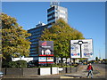
7

Birmingham : Coventry Road A45
At the traffic lights along Coventry Road.
Image: © Lewis Clarke
Taken: 1 Jul 2015
0.13 miles
8
Road sign, Willard Road
Roadsign on corner of Coventry Road and cul-de-sac Willard Road, showing route of outer-ring-road to Stechford, Yardley, South Yardley, Acock's Green and Hall Green
Swan offices in background
Image: © Michael Westley
Taken: 25 Oct 2010
0.13 miles
9

OS benchmark - Hay Mills, former police station
This OS cutmark lies beside the front door of the former Hay Mills police station, which has now been converted into the Old Bill and Bull pub. It was originally levelled in 1965 at 126.03m above Ordnance Datum Newlyn.
Image: © Richard Law
Taken: 24 Nov 2014
0.14 miles
10

Old Bill and Bull
Large public house, converted from former police station on main A45 Coventry Road, near Yardley
Image: © Michael Westley
Taken: 4 May 2011
0.14 miles