IMAGES TAKEN NEAR TO
Ivyfield Road, BIRMINGHAM, B23 7HS
Introduction
This page details the photographs taken nearby to Ivyfield Road, B23 7HS by members of the Geograph project.
The Geograph project started in 2005 with the aim of publishing, organising and preserving representative images for every square kilometre of Great Britain, Ireland and the Isle of Man.

There are currently over 7.5m images from over14,400 individuals and you can help contribute to the project by visiting https://www.geograph.org.uk
Image Map
Images are licensed for reuse under creativecommons.org/licenses/by-sa/2.0
Notes
- Clicking on the map will re-center to the selected point.
- The higher the marker number, the further away the image location is from the centre of the postcode.
Image Listing (10 Images Found)
Images are licensed for reuse under creativecommons.org/licenses/by-sa/2.0
Image
Details
Distance
1
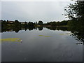
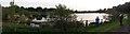
Middle Witton Reservoir
The western-most of the two lakes near Short Heath, the other being Image, and the third being Image which was formerly known as Lower Witton Reservoir. All were created around the middle of the 19th century by the City Corporation to provide a water supply to Brum, at a time when the streams feeding them ran through clean agricultural land. When that ceased to be the case, the Victorians piped water into the city from mid Wales (the Elan Valley complex) and the old reservoirs are now a wildfowl reserve and boating amenity.
Image: © Richard Law
Taken: 9 Aug 2018
0.09 miles

3
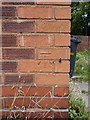
OS benchmark - Upper Witton, 153 Gipsy Lane
An OS cutmark on the front wall of no 153 Gipsy Lane; originally levelled, probably in 1956, at 103.37m above Ordnance Datum Newlyn.
Image: © Richard Law
Taken: 9 Aug 2018
0.15 miles
4
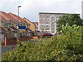
Wyrley Birch
The housing blocks of Wyrley Birch are visible throughout the surrounding area but this was the first time I'd found the road that goes right up to them. It's often cited as a "problem estate" and maybe its inaccessibility is part of the problem. But it's in a nice location; behind me when I took this shot were the lakes and park.
Image: © Adrian Bailey
Taken: 14 Jul 2005
0.19 miles
5
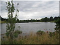
From water supply to a walk in the park - Witton Lakes, Birmingham
Witton Lakes were created in the 19th century as drinking water reservoirs and served this purpose until superseded by the supply from the Elan Valley reservoirs. The North Birmingham Cycle/Walk Route - no. 535 from Sutton Coldfield to Birmingham - passes through the area. Time photo taken 2.55 pm BST (British Summer Time).
Image
Image: © Martin Richard Phelan
Taken: 9 Aug 2013
0.20 miles
6
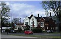
The Hare and Hounds, Marsh Hill
Pub on main outer-ring road, A4040 near Erdington
Image: © Michael Westley
Taken: 25 Apr 2010
0.21 miles
7
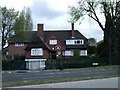
Day Nursery, Marsh Hill
Nursery on Marsh Hill, at junction with Ivyfield Road
Image: © Michael Westley
Taken: 25 Apr 2010
0.22 miles
9
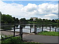
View from the dam - Witton Lakes, Birmingham
Witton Lakes were created in the 19th century as drinking water reservoirs and served this purpose until superseded by the supply from the Elan Valley reservoirs. The North Birmingham Cycle/Walk Route - no. 535 from Sutton Coldfield to Birmingham - passes through the area. Time photo taken 3.31 pm BST (British Summer Time).
Image: © Martin Richard Phelan
Taken: 4 Jun 2012
0.25 miles
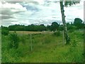
10
Witton Lakes, off Perry Common Road
Wildlife and humanity in harmony
Image: © Michael Westley
Taken: 8 May 2016
0.25 miles