IMAGES TAKEN NEAR TO
Marshmont Way, BIRMINGHAM, B23 5YN
Introduction
This page details the photographs taken nearby to Marshmont Way, B23 5YN by members of the Geograph project.
The Geograph project started in 2005 with the aim of publishing, organising and preserving representative images for every square kilometre of Great Britain, Ireland and the Isle of Man.

There are currently over 7.5m images from over14,400 individuals and you can help contribute to the project by visiting https://www.geograph.org.uk
Image Map
Images are licensed for reuse under creativecommons.org/licenses/by-sa/2.0
Notes
- Clicking on the map will re-center to the selected point.
- The higher the marker number, the further away the image location is from the centre of the postcode.
Image Listing (2 Images Found)
Images are licensed for reuse under creativecommons.org/licenses/by-sa/2.0
Image
Details
Distance
1
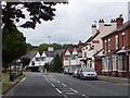
Court Lane
Looking north, at the point where the road leaves Birmingham and enters Sutton.
Image: © Adrian Bailey
Taken: 17 Jun 2005
0.20 miles
2
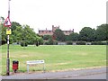
Oscott College
a.k.a. St Mary's Roman Catholic Seminary. Viewed from the new housing estate to the south.
Image: © Adrian Bailey
Taken: 17 Jun 2005
0.20 miles