IMAGES TAKEN NEAR TO
Witton Lodge Road, BIRMINGHAM, B23 5LT
Introduction
This page details the photographs taken nearby to Witton Lodge Road, B23 5LT by members of the Geograph project.
The Geograph project started in 2005 with the aim of publishing, organising and preserving representative images for every square kilometre of Great Britain, Ireland and the Isle of Man.

There are currently over 7.5m images from over14,400 individuals and you can help contribute to the project by visiting https://www.geograph.org.uk
Image Map
Images are licensed for reuse under creativecommons.org/licenses/by-sa/2.0
Notes
- Clicking on the map will re-center to the selected point.
- The higher the marker number, the further away the image location is from the centre of the postcode.
Image Listing (8 Images Found)
Images are licensed for reuse under creativecommons.org/licenses/by-sa/2.0
Image
Details
Distance
1
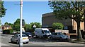
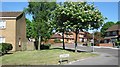
Oscott Social Club, Short Heath
Social Club on Witton Lodge Road
Image: © Michael Westley
Taken: 22 May 2010
0.18 miles
2
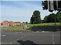
NCN on Witton Lodge Road - Perry Common, Birmingham
National Cycle Network route number 535 crosses Witton Lodge Road here on its way between Birmingham and Sutton Coldfield. The route is maintained by Sustrans full-time staff based in Digbeth and local volunteer rangers. Time taken 9.55 am BST (British Summer Time).
Image: © Martin Richard Phelan
Taken: 2 Jul 2014
0.18 miles
3
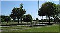
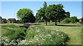
Witton Lodge Road
Recreation grounds and grass areas either side of this road
Image: © Michael Westley
Taken: 22 May 2010
0.20 miles
4
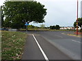
Maxted Road joins Witton Lodge Road
At the northern end of the Perry Common Recreation Ground, the open space on the far side of the junction. It's currently fenced off whilst extensive landscaping and redevelopment of the 'rec' takes place.
Image: © Richard Law
Taken: 9 Aug 2018
0.21 miles
5
Church Acre, Perry Common
Cul-de-sac near grassy area, close to The Hurstway
Image: © Michael Westley
Taken: 22 May 2010
0.22 miles
6
Recreational area, Short Heath
Stream runs through recreational ground between Short Heath Road and here near Witton Lodge Road.
Image: © Michael Westley
Taken: 22 May 2010
0.23 miles
7
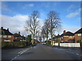
Midday Christmas 2012 :: Flackwell Road Erdington
Flackwell Road at crossroad with Chipstead Road Erdington, Midday Christmas 2012
Image: © Roy Hughes
Taken: 25 Dec 2012
0.24 miles
8

The Farm Labourer's cottage in Short Heath
A remarkable survivor of earlier days, albeit rather hard to 'see'. These roofs are those of a Grade II listed https://britishlistedbuildings.co.uk/101276193-farm-labourers-cottage-erdington-ward#.W6UNo9QrLGg late 18th century labourer's cottage on Jerry's Lane, formerly Turf Pits Lane. The listing detail, after the normal cold and factual description of the house, rather more prosaically states "[this] is a very rare survival of an unaltered small dwelling of the most primitive type, and represents a level of housing provision now almost completely lost in both urban and rural contexts"
Image: © Richard Law
Taken: 9 Aug 2018
0.24 miles