IMAGES TAKEN NEAR TO
Hutton Road, BIRMINGHAM, B20 3RE
Introduction
This page details the photographs taken nearby to Hutton Road, B20 3RE by members of the Geograph project.
The Geograph project started in 2005 with the aim of publishing, organising and preserving representative images for every square kilometre of Great Britain, Ireland and the Isle of Man.

There are currently over 7.5m images from over14,400 individuals and you can help contribute to the project by visiting https://www.geograph.org.uk
Image Map
Images are licensed for reuse under creativecommons.org/licenses/by-sa/2.0
Notes
- Clicking on the map will re-center to the selected point.
- The higher the marker number, the further away the image location is from the centre of the postcode.
Image Listing (17 Images Found)
Images are licensed for reuse under creativecommons.org/licenses/by-sa/2.0
Image
Details
Distance
1
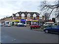
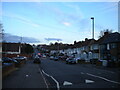
Shops in Church Hill
At the junction of several residential roads, most notably the corner of Wilson and Hutton Roads.
Image: © Richard Law
Taken: 1 Feb 2017
0.07 miles
2
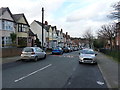
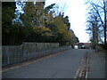
Robert Road, Church Hill
1930s housing on Robert Road, which leads NW to Wilton Road.
Image: © Richard Law
Taken: 1 Feb 2017
0.14 miles
3
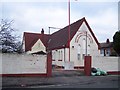
Sachkhand Nanak Dham International Sikh Temple, Handsworth
Image: © Geoff Pick
Taken: 11 Jan 2011
0.18 miles
4
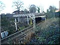
Road Bridge, Wellington Road, Handsworth Wood
View from Manwoods Close of railway running under Wellington Road in direction of Hamstead.
Image: © Michael Westley
Taken: 17 Jan 2010
0.19 miles
5
Trinity Way, Handsworth Wood
Off Hamstead Road.
Image: © Richard Vince
Taken: 19 Nov 2022
0.20 miles
6
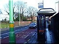
Bus Stop, Wellington Road
Bus stop on road bridge over railway line on A4040 Wellington Road, near Upper Grosvenor Road. The railway line crosses under diagonally, as can be seen by the railway wall opposite.
Image: © Michael Westley
Taken: 17 Jan 2010
0.21 miles
7
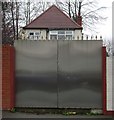
Front gate, Hamstead Road, Handsworth
The exception, not the rule.
Image: © Robin Stott
Taken: 17 Nov 2008
0.21 miles
8
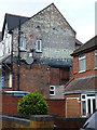
Ghost writing on a gable wall
At the western end of Church Hill Road, the lettering implies that assorted confectionery and cigarettes have been available here for some while, and it's still trading as a corner store and newsagent. The name Bull Flake seems to emerge from the paintwork after a short while, but an online search for that brand name doesn't reveal much history.
Image: © Richard Law
Taken: 1 Feb 2017
0.21 miles
10
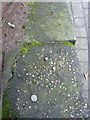
OS rivet benchmark - Church Hill, boundary wall of hall
An OS rivet and (rather faded) arrow on the coping stone of the boundary wall of the small hall attached to Image Originally levelled, probably in 1956, at 199.04m above Ordnance Datum Newlyn.
Image: © Richard Law
Taken: 1 Feb 2017
0.22 miles