IMAGES TAKEN NEAR TO
Thomas George Way, BIRMINGHAM, B19 2NE
Introduction
This page details the photographs taken nearby to Thomas George Way, B19 2NE by members of the Geograph project.
The Geograph project started in 2005 with the aim of publishing, organising and preserving representative images for every square kilometre of Great Britain, Ireland and the Isle of Man.

There are currently over 7.5m images from over14,400 individuals and you can help contribute to the project by visiting https://www.geograph.org.uk
Image Map
Images are licensed for reuse under creativecommons.org/licenses/by-sa/2.0
Notes
- Clicking on the map will re-center to the selected point.
- The higher the marker number, the further away the image location is from the centre of the postcode.
Image Listing (44 Images Found)
Images are licensed for reuse under creativecommons.org/licenses/by-sa/2.0
Image
Details
Distance
1
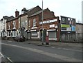
Another closed pub
The Cross Guns public house on Rodway Close in Newtown.
Image: © Carl Baker
Taken: 5 Sep 2006
0.03 miles
2
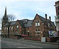
Aston-Six Ways
Former Christ Church Baptist Chapel restored and converted to private residencies.Image
Image: © Ian Rob
Taken: 26 Feb 2011
0.08 miles
4
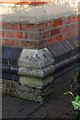
Benchmark on #2 Victoria Road
Ordnance Survey cut mark benchmark described on the Bench Mark Database at http://www.bench-marks.org.uk/bm63006
Image: © Roger Templeman
Taken: 20 Dec 2014
0.09 miles
5
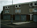
Ready for demolition
These late 1960s houses on Alma Way are now ready for demolition.
Image: © Carl Baker
Taken: 5 Sep 2006
0.10 miles
6
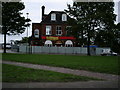
Another pub closes down
The former public house the Royal Oak on Lozells Road.
Image: © Carl Baker
Taken: 5 Sep 2006
0.10 miles
7
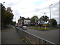
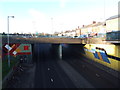
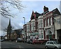
West end of Lozells Road, Aston
Looking towards Lozells from Six Ways roundabout.
Image: © Richard Vince
Taken: 26 Oct 2013
0.10 miles
8
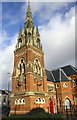
Tower and spire of #2 Victoria Road, formerly Christchurch
There is an OS benchmark Image at the base of the tower at its near corner
Image: © Roger Templeman
Taken: 20 Dec 2014
0.10 miles
9
Aston-Jamiah Masjid Mohiuddin Siddiquia Mosque
Mosque and Community Centre in Victoria Road.
Image: © Ian Rob
Taken: 26 Feb 2011
0.11 miles
10
Aston-Victoria Road
Post Box and small engineering company.
Image: © Ian Rob
Taken: 26 Feb 2011
0.11 miles