IMAGES TAKEN NEAR TO
Harold Road, BIRMINGHAM, B16 9DN
Introduction
This page details the photographs taken nearby to Harold Road, B16 9DN by members of the Geograph project.
The Geograph project started in 2005 with the aim of publishing, organising and preserving representative images for every square kilometre of Great Britain, Ireland and the Isle of Man.

There are currently over 7.5m images from over14,400 individuals and you can help contribute to the project by visiting https://www.geograph.org.uk
Image Map
Images are licensed for reuse under creativecommons.org/licenses/by-sa/2.0
Notes
- Clicking on the map will re-center to the selected point.
- The higher the marker number, the further away the image location is from the centre of the postcode.
Image Listing (66 Images Found)
Images are licensed for reuse under creativecommons.org/licenses/by-sa/2.0
Image
Details
Distance
1
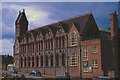
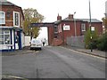
Ladywood School, Follett Osler Building, Birmingham
The former Follett Osler School [before that it was Osler St] in use as an annexe to Ladywood Comprehensive School seen here in 1973. The picture is taken across Clark St before the whole area was redeveloped into housing.
Image: © Rob Newman
Taken: Unknown
0.07 miles
2
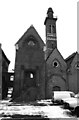
Edgbaston Waterworks
The beam engine house just coming into view on the left has now been demolished but the other engine house, boiler house and chimney all survive and I believe they are listed.
Image: © Chris Allen
Taken: 17 Feb 1985
0.09 miles
3
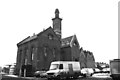
Edgbaston Waterworks
This is obviously a range of beam engine houses and boiler house with very ornate chimney. I believe one of the engine houses has been demolished.
Image: © Chris Allen
Taken: 17 Feb 1985
0.10 miles
4
Edgbaston Waterworks
The water pumping station at Edgbaston was built by Birmingham Corporation in 1862 to designs by John Henry Chamberlain. The chimney resembles a campanile or bell tower in Italian gothic style; it can be seen rising above the roofs of the waterworks building in this photo, and it is a listed building, described at the Historic England site https://historicengland.org.uk/listing/the-list/list-entry/1343154?section=official-list-entry . The building in the foreground is not included in the listing. Its distinctive modernist style suggests a date in the 1920s or 1930s.
Image: © A J Paxton
Taken: 21 Mar 2022
0.12 miles
6
Reservoir Cafe and Lodge, Edgbaston Reservoir
This is the main public entrance to Edgbaston Reservoir, which was constructed in the late 1820s by Thomas Telford to supply water to his improved Birmingham canal navigation. The Lodge was built at the same time and enlarged later in the 19th century.
Image: © A J Paxton
Taken: 2 Apr 2022
0.13 miles
7
Reservoir gateway - Edgbaston, Birmingham
Entrance to Edgbaston Reservoir and Park, managed by Birmingham City Council Parks Department. The Reservoir, also once known as Rotton Park Reservoir, was built by Thomas Telford in 1827 as a top-up feeder for the Birmingham Canal Network. Time taken 12.50 pm GMT (Greenwich Mean Time).
Image: © Martin Richard Phelan
Taken: 15 Nov 2012
0.13 miles
9
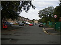
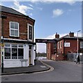
Oliver Road, Ladywood
Off the disconnected north end of Monument Road.
Image: © Richard Vince
Taken: 11 Sep 2021
0.14 miles
10
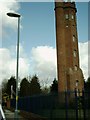
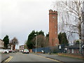
One of the Two Towers?
Perrott's Folly built in 1758 by John Perrott.
Image: © Carl Baker
Taken: 15 Apr 2006
0.14 miles