IMAGES TAKEN NEAR TO
Summerfield Crescent, BIRMINGHAM, B16 0EN
Introduction
This page details the photographs taken nearby to Summerfield Crescent, B16 0EN by members of the Geograph project.
The Geograph project started in 2005 with the aim of publishing, organising and preserving representative images for every square kilometre of Great Britain, Ireland and the Isle of Man.

There are currently over 7.5m images from over14,400 individuals and you can help contribute to the project by visiting https://www.geograph.org.uk
Image Map (Loading...)


Getting Data...Please wait
Leaflet Map data © OpenStreetMap
Images are licensed for reuse under creativecommons.org/licenses/by-sa/2.0
Notes
- Clicking on the map will re-center to the selected point.
- The higher the marker number, the further away the image location is from the centre of the postcode.
Image Listing (63 Images Found)
Images are licensed for reuse under creativecommons.org/licenses/by-sa/2.0
Image
Details
Distance
1

Christ Church, Summerfield, near Rotton Park
A large church, built in the early 1880s in the 'Perpendicular' style and designed by the architect Julius Alfred Chatwin. It was constructed at the time this area was being built up with housing for the workers of the city, and attracted a Grade II listing https://britishlistedbuildings.co.uk/101076167-christ-church-ladywood-ward#.XxBU7yhKjcs & https://historicengland.org.uk/listing/the-list/list-entry/1076167 in 1982.
Image: © Richard Law
Taken: 8 Jan 2020
0.07 miles

3
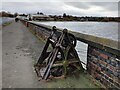
Along the dam, Edgbaston Reservoir
This is a view from the footpath across the dam, looking north towards the buildings by the Midlands Sailing Club. The reservoir was built in the 1820s by Thomas Telford to supply water to canals.
Image: © A J Paxton
Taken: 2 Apr 2022
0.12 miles

6
Path along the dam at Edgbaston Reservoir
Image: © Mat Fascione
Taken: 17 Nov 2020
0.14 miles


9
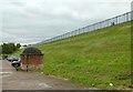
Dam wall, Edgbaston Reservoir
The reservoir was created in 1827 by Thomas Telford to supply water to the Birmingham Canal.
Image: © Alan Murray-Rust
Taken: 21 Oct 2015
0.14 miles
10
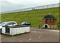
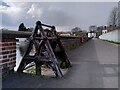
Valve house, Edgbaston Reservoir
An attractive circular building. This is part-way up the dam of the reservoir and provided feed to the summit (Wolverhampton Level) of the Birmingham Canal via the Engine Arm branch. The walled enclosure in the foreground allows water to be directed either into the feeder or down to the Birmingham Level on the Icknield Port Loop.
Image: © Alan Murray-Rust
Taken: 21 Oct 2015
0.15 miles