IMAGES TAKEN NEAR TO
Belstone Close, BIRMINGHAM, B14 6UB
Introduction
This page details the photographs taken nearby to Belstone Close, B14 6UB by members of the Geograph project.
The Geograph project started in 2005 with the aim of publishing, organising and preserving representative images for every square kilometre of Great Britain, Ireland and the Isle of Man.

There are currently over 7.5m images from over14,400 individuals and you can help contribute to the project by visiting https://www.geograph.org.uk
Image Map (8 Images)


Getting Data...Please wait
Leaflet Map data © OpenStreetMap
Images are licensed for reuse under creativecommons.org/licenses/by-sa/2.0
Notes
- Clicking on the map will re-center to the selected point.
- The higher the marker number, the further away the image location is from the centre of the postcode.
Image Listing (8 Images Found)
Images are licensed for reuse under creativecommons.org/licenses/by-sa/2.0
Image
Details
Distance
1
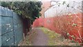
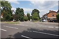
Path Linking Harton Way with Dawberry Road
This path existed when this area was agricultural land. Now it is an unassuming alleyway and serves merely to link residential roads. It runs from Dawberry Fields Road to Harton Way and on through to Dawberry Road. Beyond the red wall in the photo, where a house is visible, there was once a large brickworks which the path skirted.
Image: © Paul Collins
Taken: 10 Mar 2017
0.09 miles
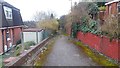
2
Path passing the end of Harton Way
This path existed when this area was agricultural land. Now it is an unassuming alleyway and serves merely to link residential roads. It runs from Dawberry Fields Road to Harton Way (running off to the left) and on through to Dawberry Road past the site of a former brickworks.
Image: © Paul Collins
Taken: 10 Mar 2017
0.12 miles
3
Path Linking Dawberry Fields Road with Dawberry Road
This path existed when this area was agricultural land. Now it is an unassuming alleyway and serves merely to link residential roads. It runs from Dawberry Fields Road (from where the image was taken) to Harton Way and on through to Dawberry Road.
Image: © Paul Collins
Taken: 10 Mar 2017
0.12 miles
4
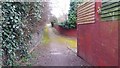
Path Linking Harton Way with Dawberry Fields Road
This path existed when this area was agricultural land. Now it is an unassuming alleyway and serves merely to link residential roads. It runs from Dawberry Road to Harton Way (running off to the right in the middle distance) and on through to Dawberry Fields Road.
Image: © Paul Collins
Taken: 10 Mar 2017
0.15 miles
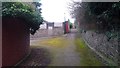
6
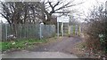
Entrance to Dawberry Fields Neighbourhood Park
This is the Dawberry Fields Road entrance to a park that was laid out with paths, a skate bowl and play area in about 2010. At the times of my three visits it has been somewhat marred by an excess of litter. In days of yore the road continued beyond the fencing and is there locally known as Piggy Lane.
Image: © Paul Collins
Taken: 10 Mar 2017
0.24 miles
7
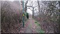
Path Linking Dawberry Fields Road with Shalnecote Grove
This short path has rather a rural feel although this may not last - the land on the right will probably be developed in future.
Image: © Paul Collins
Taken: 10 Mar 2017
0.25 miles
8
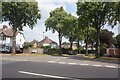
Featherstone Road off Brandwood Road, Birmingham
Image: © Ian S
Taken: 26 Jul 2021
0.25 miles