IMAGES TAKEN NEAR TO
Westhouse Grove, BIRMINGHAM, B14 6PT
Introduction
This page details the photographs taken nearby to Westhouse Grove, B14 6PT by members of the Geograph project.
The Geograph project started in 2005 with the aim of publishing, organising and preserving representative images for every square kilometre of Great Britain, Ireland and the Isle of Man.

There are currently over 7.5m images from over14,400 individuals and you can help contribute to the project by visiting https://www.geograph.org.uk
Image Map
Images are licensed for reuse under creativecommons.org/licenses/by-sa/2.0
Notes
- Clicking on the map will re-center to the selected point.
- The higher the marker number, the further away the image location is from the centre of the postcode.
Image Listing (11 Images Found)
Images are licensed for reuse under creativecommons.org/licenses/by-sa/2.0
Image
Details
Distance
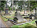
2

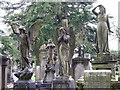
Brandwood End Cemetery, entrance and mortuary chapels
Listed buildings, seen here from the cemetery side. Restoration is proposed.
When it was opened in 1899 the cemetery was administered by King's Norton Rural District Council, and was absorbed by Birmingham when the city extended its boundaries in 1911. It covers an area of over 21 hectares. It is accorded a Grade II on the Register of Parks and Gardens of Special Historic Interest in England [source: Birmingham City Council].
Image: © Robin Stott
Taken: 9 Apr 2009
0.23 miles
3
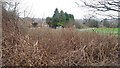
Japanese Knotweed at Shalnecote Grove
This clump of Japanese Knotweed has fortunately been sprayed. The green space visible on the right is Dawberry Fields Neighbourhood Park.
Image: © Paul Collins
Taken: 10 Mar 2017
0.23 miles
4
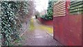
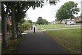
Path Linking Harton Way with Dawberry Fields Road
This path existed when this area was agricultural land. Now it is an unassuming alleyway and serves merely to link residential roads. It runs from Dawberry Road to Harton Way (running off to the right in the middle distance) and on through to Dawberry Fields Road.
Image: © Paul Collins
Taken: 10 Mar 2017
0.23 miles
5
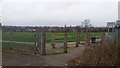
Entrance to Dawberry Fields Neighbourhood Park
This is the entrance from Shalnacote Grove.
Image: © Paul Collins
Taken: 10 Mar 2017
0.23 miles
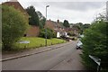
6
Brandwood Park Road, Brandwood End, Birmingham
Image: © Ian S
Taken: 20 Aug 2021
0.23 miles
8
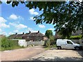
Parking behind 54-56 Brandwood Park Road
Image: © Alex McGregor
Taken: 22 Jul 2014
0.24 miles
10
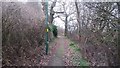
Path Linking Dawberry Fields Road with Shalnecote Grove
This short path has rather a rural feel although this may not last - the land on the right will probably be developed in future.
Image: © Paul Collins
Taken: 10 Mar 2017
0.24 miles