IMAGES TAKEN NEAR TO
Druids Lane, BIRMINGHAM, B14 5QF
Introduction
This page details the photographs taken nearby to Druids Lane, B14 5QF by members of the Geograph project.
The Geograph project started in 2005 with the aim of publishing, organising and preserving representative images for every square kilometre of Great Britain, Ireland and the Isle of Man.

There are currently over 7.5m images from over14,400 individuals and you can help contribute to the project by visiting https://www.geograph.org.uk
Image Map
Images are licensed for reuse under creativecommons.org/licenses/by-sa/2.0
Notes
- Clicking on the map will re-center to the selected point.
- The higher the marker number, the further away the image location is from the centre of the postcode.
Image Listing (8 Images Found)
Images are licensed for reuse under creativecommons.org/licenses/by-sa/2.0
Image
Details
Distance
1

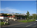
Bells Farm
This farmhouse dates from the 16th Century and is Grade II* Listed. It gives its name to the surrounding housing developments. It was restored in 1988 and is used for educational purposes.
Image: © David Stowell
Taken: 26 May 2006
0.09 miles
2

Bells Lane turning circle, Druids Heath
Built into the junction with Druids Lane (foreground), this turning circle is the outer terminus for route 50, which is probably still the most frequent bus route in Britain (in terms of frequency along the whole route). Because of the route's high frequency, it was once usual to find two or three buses sitting in the turning circle during the day, but when I took this picture the buses weren't hanging around.
Image: © Richard Vince
Taken: 8 Dec 2012
0.10 miles
3
Disused petrol filling station, Bells Lane
A fairly modern but closed filling station in Bells Lane. It is probably no coincidence that a large supermarket has opened further along Bells Lane at the Maypole junction!
Image: © David Stowell
Taken: 26 May 2006
0.10 miles
4
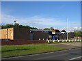
King's Norton British Legion
Beside Bells Lane.
Image: © David Stowell
Taken: 26 May 2006
0.10 miles
5

Bell's Farmhouse, Walker's Heath
A remarkable survivor in the middle of the urban landscape; this is a late 16th century timber-framed farmhouse (at one time in the relatively recent past it was rendered in roughcast cement, but this has been removed), which contains a number of original features internally. It was Grade II* listed https://britishlistedbuildings.co.uk/101075751-bells-farmhouse-brandwood-ward#.XygzSChKjcs & https://historicengland.org.uk/listing/the-list/list-entry/1075751 in 1952. It's now in use for educational purposes.
Image: © Richard Law
Taken: 29 Jan 2020
0.13 miles
6

Bells Farm
Bells Farm, original farm building range has been demolished. Farmhouse now a community centre
Image: © P Gaskell
Taken: Unknown
0.13 miles
7
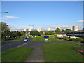
View east from Bells Lane
Looking along Bells Lane towards the blocks of flats in Druids Heath and showing some of the 1960s housing development to the right. By more recent standards these developments have been laid out with a remarkably large amount of green space.
Image: © David Stowell
Taken: 26 May 2006
0.16 miles
8
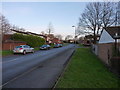
Brockworth Road, Walker's Heath
Housing developments (1970s, or thereabouts, by the look of them) in the Walker's Heath area.
Image: © Richard Law
Taken: 29 Jan 2020
0.20 miles