IMAGES TAKEN NEAR TO
Westridge Road, BIRMINGHAM, B13 0DU
Introduction
This page details the photographs taken nearby to Westridge Road, B13 0DU by members of the Geograph project.
The Geograph project started in 2005 with the aim of publishing, organising and preserving representative images for every square kilometre of Great Britain, Ireland and the Isle of Man.

There are currently over 7.5m images from over14,400 individuals and you can help contribute to the project by visiting https://www.geograph.org.uk
Image Map
Images are licensed for reuse under creativecommons.org/licenses/by-sa/2.0
Notes
- Clicking on the map will re-center to the selected point.
- The higher the marker number, the further away the image location is from the centre of the postcode.
Image Listing (5 Images Found)
Images are licensed for reuse under creativecommons.org/licenses/by-sa/2.0
Image
Details
Distance
1
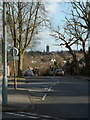
Colebourne Road
Looking down Colebourne Road at the junction with Brook Lane in Hall Green Birmingham. In the distance, the spire of St Peter's Church can be seen towering above the landscape.
Image: © Simon Dean
Taken: 27 Feb 2005
0.09 miles
2
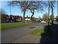
Junction of 'Old' Brook Lane with the newer road
Brook Lane is the name given to both parts of the road around here. The white car is parked on what appears to be an older alignment of the lane, and the main thoroughfare is just to the left of the photo, i.e. with the houses fronting onto it. My guess is that the new road was put in, close to the original rural lane, to better serve the area when the houses were built in the late 1930s or early 1940s.
Image: © Richard Law
Taken: 18 Apr 2018
0.10 miles

4
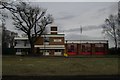
Billesley fire station
Billesley fire station, Brook Lane, Billesley, Birmingham, part of West Midlands Fire & Rescue Service
Image: © Kevin Hale
Taken: 31 Jan 2010
0.24 miles
5
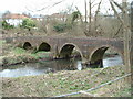
Four Arches Bridge
This is the old four arches bridge. Previously, this used to link Webb Lane and the Old Brook Lane. There is evidence of a tunnel under the railway line, but this eventually became disused. The Four Arches bridge now provides a footpath between Coleside Avenue and the Dingles Recreation ground in Hall Green across the River Cole.
Image: © Simon Dean
Taken: 20 Feb 2005
0.24 miles