IMAGES TAKEN NEAR TO
Civic Close, BIRMINGHAM, B1 2NT
Introduction
This page details the photographs taken nearby to Civic Close, B1 2NT by members of the Geograph project.
The Geograph project started in 2005 with the aim of publishing, organising and preserving representative images for every square kilometre of Great Britain, Ireland and the Isle of Man.

There are currently over 7.5m images from over14,400 individuals and you can help contribute to the project by visiting https://www.geograph.org.uk
Image Map (Loading...)


Getting Data...Please wait
Leaflet Map data © OpenStreetMap
Images are licensed for reuse under creativecommons.org/licenses/by-sa/2.0
Notes
- Clicking on the map will re-center to the selected point.
- The higher the marker number, the further away the image location is from the centre of the postcode.
Image Listing (1813 Images Found)
Images are licensed for reuse under creativecommons.org/licenses/by-sa/2.0
Image
Details
Distance
1

The Flapper inn sign
When built as part a rejuvenation programme of the area in around 1970 this new pub was originally canal 'The Longboat', today it is named 'The Flapper'
Image: © Philip Halling
Taken: 5 Mar 2023
0.01 miles
2
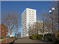
The Civic Centre Estate in Birmingham
Looking north-east across Cambridge Street.
The Civic Centre Estate is a canal-side collection of four tower blocks in Birmingham city centre, by the International Convention Centre and overlooking the Cambrian Wharf and the top four Farmer's Bridge Locks. The nearest one is Galton Tower.
They were built between 1966 and 1969, and refurbished in 2006-2009.
They contain 16 (Brindley Close) and 15 (Civic Drive) storeys, but appear identical from the outside.
Image: © Roger Kidd
Taken: 27 Feb 2022
0.02 miles
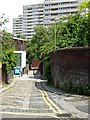
3
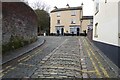
Kingston Row
Kingston Row, a traditional street with brick setts, near the Fazeley and Birmingham Canal.
Image: © Philip Halling
Taken: 5 Mar 2023
0.02 miles
4

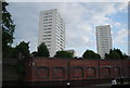
Galton Tower (detail) in Birmingham city centre
The Civic Centre Estate is a canal-side collection of four tower blocks in Birmingham city centre, by the International Convention Centre and overlooking the Cambrian Wharf and the top four Farmer's Bridge Locks. From west to east are Galton Tower, Norton Tower, Crescent Tower, and Cambridge Tower.
They were built between 1966 and 1969, and refurbished in 2006-2009.
They contain 16 (Brindley Close) and 15 (Civic Drive) storeys, but appear identical from the outside.
Image]
Image: © Roger Kidd
Taken: 27 Feb 2022
0.02 miles
7
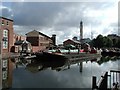
Cambrian Wharf
The basin full of working narrowboats at the heart of the canal network.
Image: © David Stowell
Taken: 27 Jul 2003
0.02 miles
8
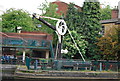
Tindal Bridge Milepost.
Newish street furniture on the Birmingham Canal Navigation between Gas Street Basin and Farmer's Bridge. The city centre towpath and canalside have been refurbished for early 21st Century Leisure.
Image: © Colin Smith
Taken: Unknown
0.02 miles
9
Civic Centre Estate, Birmingham
The tower blocks of central Birmingham's Civic Centre Estate seen from the end of Kingston Row.
Image: © Stephen McKay
Taken: 11 Jun 2006
0.02 miles
10
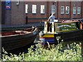
Boating through Birmingham
A traditional narrowboat tows the shell of another towards the top of the Farmer's Bridge lock flight.
Image: © Stephen McKay
Taken: 11 Jun 2006
0.02 miles