IMAGES TAKEN NEAR TO
John Bright Street, BIRMINGHAM, B1 1BE
Introduction
This page details the photographs taken nearby to John Bright Street, B1 1BE by members of the Geograph project.
The Geograph project started in 2005 with the aim of publishing, organising and preserving representative images for every square kilometre of Great Britain, Ireland and the Isle of Man.

There are currently over 7.5m images from over14,400 individuals and you can help contribute to the project by visiting https://www.geograph.org.uk
Image Map
Images are licensed for reuse under creativecommons.org/licenses/by-sa/2.0
Notes
- Clicking on the map will re-center to the selected point.
- The higher the marker number, the further away the image location is from the centre of the postcode.
Image Listing (2280 Images Found)
Images are licensed for reuse under creativecommons.org/licenses/by-sa/2.0
Image
Details
Distance
1
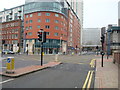
Navigation Street, junction with Hill Street, Birmingham
Image: © Stacey Harris
Taken: 27 Jan 2009
0.02 miles
2
Navigation Street, Hill Street, Birmingham
View from Ethel Street looking across to phase 1 and 2 of the Orion development on Hill Street and Navigation Street.
The bus in foreground is crossing the bridge across the west end of New Street Station.
Image: © Michael Westley
Taken: 8 Jun 2007
0.02 miles
3
Western edge of Birmingham New Street railway station
Looking beyond Navigation Street bridge towards the tunnels at the western end of the station.
There is a black horse sculpture http://www.geograph.org.uk/photo/1526168 on the platform on the right side of the tracks.
Image: © Jaggery
Taken: 5 May 2012
0.02 miles
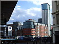
4
Mailbox View
The view from Navigation Street over the A38 towards The Mailbox in Birmingham city centre.
Image: © Gordon Griffiths
Taken: 25 Feb 2015
0.02 miles
5
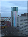
The Orion Building at twilight
The LED panels have just been turned on to add a bit of zing to the 28 storey residential block on the corner of Suffolk Street Queensway and Navigation Street. This view from the 9th floor of the Crowne Plaza hotel also shows part of The Axis, formerly Stanier House, a Y-shaped block occupied by W S Atkins.
Image: © Keith Edkins
Taken: 13 Mar 2010
0.02 miles
6
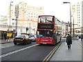
TWM Bus in Navigation St, Birmingham
Travel West Midlands bus No 4164 in Navigation St, Central Birmingham
Image: © Rob Newman
Taken: 12 Mar 2012
0.02 miles
7
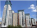
Birmingham-The Orion Building
The complex viewed across Suffolk Queensway from The Mailbox.
Image: © Ian Rob
Taken: 25 May 2013
0.03 miles
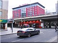
8
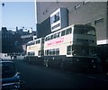
Two Buses in Birmingham City Centre
Taken in June 1969, this photo shows two Daimler Fleetline buses with Metro-Cammell 76-seater bodywork operated by Birmingham City Transport in John Bright Street. The front vehicle is 3684 (KOX 684F) on route 45 to West Heath (Alvechurch Road) via Cotteridge. This route is now operated by National Express West Midlands. John Bright Street is now a pedestrian zone.
Image: © David Hillas
Taken: 7 Jun 1969
0.03 miles
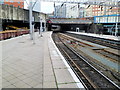
9
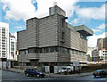
Signal box, Navigation Street, Birmingham
An intriguing slice of Brutalism, by Bicknell & Hamilton with W.R. Headley of BR's London Midland Region, 1964-65. The Pevsner City Guide describes the surface as corrugated concrete. It certainly packs a punch.
Image: © Stephen Richards
Taken: 27 Aug 2011
0.03 miles
10
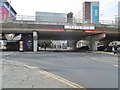
Birmingham, underpass
Taking Navigation Street under Suffolk Street Queensway towards Mailbox shopping centre.
Image: © Mike Faherty
Taken: 3 Feb 2019
0.03 miles