IMAGES TAKEN NEAR TO
Seeleys Park, Seeleys Road, BIRMINGHAM, B11 2LR
Introduction
This page details the photographs taken nearby to Seeleys Park, Seeleys Road, B11 2LR by members of the Geograph project.
The Geograph project started in 2005 with the aim of publishing, organising and preserving representative images for every square kilometre of Great Britain, Ireland and the Isle of Man.

There are currently over 7.5m images from over14,400 individuals and you can help contribute to the project by visiting https://www.geograph.org.uk
Image Map
Images are licensed for reuse under creativecommons.org/licenses/by-sa/2.0
Notes
- Clicking on the map will re-center to the selected point.
- The higher the marker number, the further away the image location is from the centre of the postcode.
Image Listing (24 Images Found)
Images are licensed for reuse under creativecommons.org/licenses/by-sa/2.0
Image
Details
Distance
1
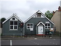
Birmingham Seventh Day Baptist Church
On Warwick Road.
Image: © JThomas
Taken: 6 May 2017
0.16 miles
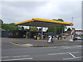
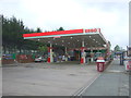
3
Warwick Road Greet - Diesel 149.9p a Litre
Image: © Roy Hughes
Taken: 3 Apr 2012
0.17 miles
7
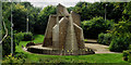
Climbing Wall
The climbing wall at the Ackers activity centre, an area designed to give inner city residents an experience of outdoor activities such as rock climbing, canoeing and skiing.
Image: © Graham Jones
Taken: 24 Aug 2017
0.18 miles