IMAGES TAKEN NEAR TO
Dorothy Road, BIRMINGHAM, B11 2ED
Introduction
This page details the photographs taken nearby to Dorothy Road, B11 2ED by members of the Geograph project.
The Geograph project started in 2005 with the aim of publishing, organising and preserving representative images for every square kilometre of Great Britain, Ireland and the Isle of Man.

There are currently over 7.5m images from over14,400 individuals and you can help contribute to the project by visiting https://www.geograph.org.uk
Image Map
Images are licensed for reuse under creativecommons.org/licenses/by-sa/2.0
Notes
- Clicking on the map will re-center to the selected point.
- The higher the marker number, the further away the image location is from the centre of the postcode.
Image Listing (32 Images Found)
Images are licensed for reuse under creativecommons.org/licenses/by-sa/2.0
Image
Details
Distance
1
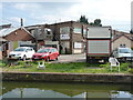
Knowing your market is important
The Birmingham Truck Stop and Barge Stop, catering for the needs of both modes of transport, and providing food, drinks and live entertainment, apparently. And some B&B facilities to boot.
Image: © Richard Law
Taken: 30 Jul 2014
0.05 miles
4
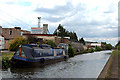
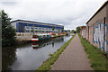
Grand Union Canal near Tyseley, Birmingham
Formerly the Warwick and Birmingham Canal.
The area is smothered in industry, at Hay Mills off to the left, and Tyseley off to the right. Most canal-side factories are either derelict, demolished, or are now cut off from all previous wharfs. New units are being built, many not showing yet on maps or available satellite images of the area.
Image: © Roger D Kidd
Taken: 21 Aug 2012
0.08 miles
5
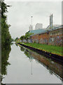
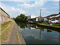
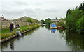
Grand Union Canal near Tyseley, Birmingham
Looking towards Birmingham on a dull wet day.
The former Warwick and Birmingham Canal was opened for business in 1800, (though ceremoniously declared open the previous year). It was bought by the Regent's Canal Company in 1929, then absorbed into the Grand Union Canal Company (GUCC) in 1932.
Image: © Roger D Kidd
Taken: 29 Aug 2012
0.11 miles
6

Grand Union Canal near Tyseley, Birmingham
Looking towards Birmingham on a dull wet day.
The former Warwick and Birmingham Canal was opened for business in 1800, (though ceremoniously declared open the previous year). It was bought by the Regent's Canal Company in 1929, then absorbed into the Grand Union Canal Company (GUCC) in 1932.
Image: © Roger D Kidd
Taken: 29 Aug 2012
0.11 miles
7
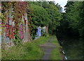
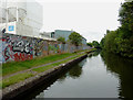
Graffitied wall along the towpath of the Grand Union Canal
The wall backs onto Birmingham's South & City College.
Image: © Mat Fascione
Taken: 29 Aug 2015
0.11 miles
8
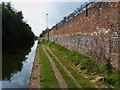
Towpath and brick wall at Tyseley
Alongside the Grand Union, this wall forms the boundary of an industrial area off Amington Road in Hay Mills; it's been heavily graffitied over the years.
Image: © Richard Law
Taken: 30 Jul 2014
0.11 miles
10
Grand Union Canal near Tyseley, Birmingham
Formerly the Warwick and Birmingham Canal.
The area is smothered in industry, at Hay Mills off to the left, and Tyseley off to the right. Most canal-side factories are either derelict, demolished, or are now cut off from all previous wharfs. New units are being built, many not showing yet on maps or available satellite images of the area.
Image: © Roger D Kidd
Taken: 21 Aug 2012
0.12 miles