IMAGES TAKEN NEAR TO
Kings Road, BIRMINGHAM, B11 2AX
Introduction
This page details the photographs taken nearby to Kings Road, B11 2AX by members of the Geograph project.
The Geograph project started in 2005 with the aim of publishing, organising and preserving representative images for every square kilometre of Great Britain, Ireland and the Isle of Man.

There are currently over 7.5m images from over14,400 individuals and you can help contribute to the project by visiting https://www.geograph.org.uk
Image Map
Images are licensed for reuse under creativecommons.org/licenses/by-sa/2.0
Notes
- Clicking on the map will re-center to the selected point.
- The higher the marker number, the further away the image location is from the centre of the postcode.
Image Listing (42 Images Found)
Images are licensed for reuse under creativecommons.org/licenses/by-sa/2.0
Image
Details
Distance
1
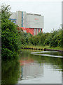
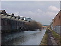
Grand Union Canal near Tyseley, Birmingham
Just coming into view is the Birmingham Energy Recycling Facility, operated by Veolia Environmental Services. Veolia's Energy Recovery Facility (ERF), converts 350,000 tonnes of Birmingham’s rubbish into electricity each year.
The former Warwick and Birmingham Canal was opened for business in 1800, (though ceremoniously declared open the previous year). It was bought by the Regent's Canal Company in 1929, then absorbed into the Grand Union Canal Company (GUCC) in 1932.
Image: © Roger D Kidd
Taken: 29 Aug 2012
0.02 miles
2
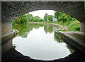
Grand Union Canal near Tyseley, Birmingham
Seen from beneath the arch of Kings Road Bridge. The considerable width of water ahead is explained by the presence of a winding hole, where boats up to seventy feet in length can be turned round.
The former Warwick and Birmingham Canal was opened for business in 1800, (though ceremoniously declared open the previous year). It was bought by the Regent's Canal Company in 1929, then absorbed into the Grand Union Canal Company (GUCC) in 1932.
Image: © Roger D Kidd
Taken: 29 Aug 2012
0.02 miles

4
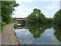
Kings Road bridge
Bridge no 88 over the canal, carrying Kings Road which connects the A45 Coventry Road about 1/4 mile to the north, with the A41 Warwick Road to the south, travelling through Hay Mills and Tyseley on the way.
Image: © Richard Law
Taken: 30 Jul 2014
0.02 miles

7
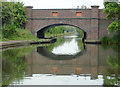
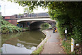
Kings Road Bridge near Tyseley, Birmingham
Bridge No 88 across the Grand Union Canal.
It will be noticed that most canals retain the old 18th and early 19th century bridges, with a navigable width of about nine to ten feet. This canal, however, (formerly the Warwick and Birmingham), was considerably modernised in the 1930s so that wider and heavier boats could use it. This included fourteen foot wide locks for pairs of narrowboats and new wider bridges. In and around Birmingham this included the provision of fireman's hatches in the parapets (seen here painted red) to allow easier access for their hoses in an emergency.
The money ran out by the time this canal reached the top of Camp Hill Locks in Birmingham, so the project was never completed.
Image: © Roger D Kidd
Taken: 21 Aug 2012
0.03 miles
8
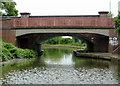
Kings Road Bridge near Tyseley, Birmingham
Bridge No 88 across the Grand Union (formerly the Warwick and Birmingham) Canal.
The former Warwick and Birmingham Canal was opened for business in 1800, (though ceremoniously declared open the previous year). It was bought by the Regent's Canal Company in 1929, then absorbed into the Grand Union Canal Company (GUCC) in 1932.
Image: © Roger D Kidd
Taken: 29 Aug 2012
0.03 miles
9
Bridge 88, Grand Union Canal
Kings Road Bridge
Image: © Tim Glover
Taken: 19 Feb 2000
0.03 miles
10
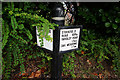
Distance post next to bridge #88 Grand Union Canal
Image: © Ian S
Taken: 28 Aug 2019
0.03 miles