IMAGES TAKEN NEAR TO
Sampson Road North, BIRMINGHAM, B11 1BG
Introduction
This page details the photographs taken nearby to Sampson Road North, B11 1BG by members of the Geograph project.
The Geograph project started in 2005 with the aim of publishing, organising and preserving representative images for every square kilometre of Great Britain, Ireland and the Isle of Man.

There are currently over 7.5m images from over14,400 individuals and you can help contribute to the project by visiting https://www.geograph.org.uk
Image Map
Images are licensed for reuse under creativecommons.org/licenses/by-sa/2.0
Notes
- Clicking on the map will re-center to the selected point.
- The higher the marker number, the further away the image location is from the centre of the postcode.
Image Listing (163 Images Found)
Images are licensed for reuse under creativecommons.org/licenses/by-sa/2.0
Image
Details
Distance
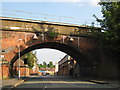
1
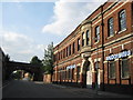
Honeyglen Anodizing
Factory on Sampson Road North, Bordesley. Beyond, the railway bridge and freight line that crosses, between Kings Heath and St Andrews junction
Image: © Michael Westley
Taken: 2 Jun 2011
0.01 miles
2
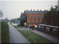
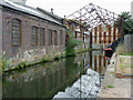
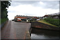
Sampson Road Wharf
The warehouses on the right were the limit of navigation for broad-beamed boats from the South following the widening of the Grand Union canal in the 1930s. The narrow lock on the right leads up from the extensive Birmingham Canal Navigations.
Image: © David Stowell
Taken: Unknown
0.02 miles
3
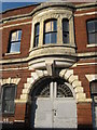
Honeyglen Anodizing
Close up of architecture of factory on Sampson Road North
Image: © Michael Westley
Taken: 2 Jun 2011
0.02 miles
5
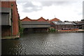
Sampson Road Wharf near Sparkbrook, Birmingham
The short arm adjacent to Camp Hill Top Lock, and the nearby warehouses were formerly a depot for the Warwick and Birmingham Canal. This was the northern limit for wider boats, traffic continuing to Birmingham being limited to a beam of seven feet. Currently the venue is used by a modern boat crew's sanitary station (off to the right). This cannot be accessed from the towpath side of the canal or the lock itself.
Image]
Image: © Roger D Kidd
Taken: 21 Aug 2012
0.02 miles
7
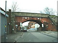
Railway Bridge
Railway bridge over Sampson Road North.
Image: © Carl Baker
Taken: 14 Apr 2006
0.03 miles
8
Sampson Road North railway bridge
Looking south-east - freight line between St Andrews junction and Moseley
Image: © Michael Westley
Taken: 2 Jun 2011
0.03 miles
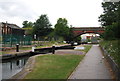
10
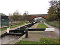
Camp Hill Top Lock, Grand Union Canal
Image: © Gareth James
Taken: 19 Nov 2011
0.03 miles