IMAGES TAKEN NEAR TO
Somerville Road, BIRMINGHAM, B10 9DX
Introduction
This page details the photographs taken nearby to Somerville Road, B10 9DX by members of the Geograph project.
The Geograph project started in 2005 with the aim of publishing, organising and preserving representative images for every square kilometre of Great Britain, Ireland and the Isle of Man.

There are currently over 7.5m images from over14,400 individuals and you can help contribute to the project by visiting https://www.geograph.org.uk
Image Map
Images are licensed for reuse under creativecommons.org/licenses/by-sa/2.0
Notes
- Clicking on the map will re-center to the selected point.
- The higher the marker number, the further away the image location is from the centre of the postcode.
Image Listing (3 Images Found)
Images are licensed for reuse under creativecommons.org/licenses/by-sa/2.0
Image
Details
Distance
1
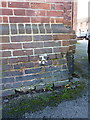
OS benchmark - Small Heath, The Monica pub
Picked out rather roughly in white paint is an OS cutmark on the NE face of The Monica; originally levelled at 110.45m above Ordnance Datum Newlyn.
Image: © Richard Law
Taken: 2 Jan 2015
0.05 miles
2
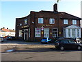
The Monica Pub, Small Heath
A little off the beaten track, The Monica lies at the junction of Somerville Road and (oddly) Monica Road.
Image: © Richard Law
Taken: 2 Jan 2015
0.06 miles
3

Digby Park, Small Heath
Small park, boundaried by housing, on Somerville Road, Small Heath.
Interesting local newspaper article about the park http://www.birminghammail.net/what-is-on-in-birmingham/best-of-birmingham/2011/01/14/walk-in-the-park-digby-park-in-small-heath-97319-27982794/
Image: © Michael Westley
Taken: 28 Mar 2011
0.23 miles