IMAGES TAKEN NEAR TO
Wellgarth, WELWYN GARDEN CITY, AL7 3AF
Introduction
This page details the photographs taken nearby to Wellgarth, AL7 3AF by members of the Geograph project.
The Geograph project started in 2005 with the aim of publishing, organising and preserving representative images for every square kilometre of Great Britain, Ireland and the Isle of Man.

There are currently over 7.5m images from over14,400 individuals and you can help contribute to the project by visiting https://www.geograph.org.uk
Image Map
Images are licensed for reuse under creativecommons.org/licenses/by-sa/2.0
Notes
- Clicking on the map will re-center to the selected point.
- The higher the marker number, the further away the image location is from the centre of the postcode.
Image Listing (27 Images Found)
Images are licensed for reuse under creativecommons.org/licenses/by-sa/2.0
Image
Details
Distance
1
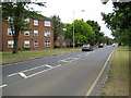
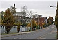
Welwyn Garden City: A1000 Broadwater Road
Viewed as the road enters the Broadwater area of Welwyn Garden City.
Image: © Nigel Cox
Taken: 2 Jul 2008
0.04 miles
3
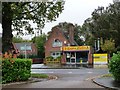
Golden Valley, Welwyn Garden City
Serving fish and chips and Chinese food, on Peartree Lane.
Image: © Christine Johnstone
Taken: 1 Nov 2013
0.12 miles
4
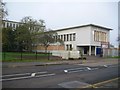
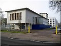
Welwyn Garden City: Former Roche Products Factory (1)
Now looking in a very sorry state with peeling render and boarded up windows this is the east end of the administration block of the former Roche Products factory on Broadwater Road. The actual factory was the four storey building behind the trees to the left. The factory was built to the designs of the Swiss architect, Otto Salvisberg, between 1938 and 1940, and is now a Grade II Listed Building.
The English Heritage web page for the building is here http://list.english-heritage.org.uk/resultsingle.aspx?uid=1348142&searchtype=mapsearch and states that "The administration block is 2-storeyed with the bronze entrance doors set well back behind pilotis and with 7 narrow, deeply set vertical windows in the wall above."
There is an aerial view of the factory in 1950 on the "Britain from Above" website here http://www.britainfromabove.org.uk/image/eaw028159
For a view of the other side of the building please see Image
Image: © Nigel Cox
Taken: 15 Nov 2014
0.13 miles
5
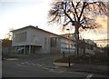
Welwyn Garden City: Former Roche Products Factory (2)
Please see Image for details and a view of the south side. This is the north facade of the administration block, described on the English Heritage website as "To the right, the principal staircase in a glazed door, the only feature to break the austerely white cubic form of the group of buildings." The yellow posts mark the entrance way to Otto Road, which was presumably named after the Swiss architect of the building, Otto Salvisberg.
Image: © Nigel Cox
Taken: 15 Nov 2014
0.13 miles
6
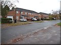
Houses on the west side of Mill Green Road
Built in blocks of four. Does this make them a terrace?
Image: © Christine Johnstone
Taken: 1 Nov 2013
0.14 miles
7
Offices on Broadwater Road, Welwyn Garden City
Image: © David Howard
Taken: 25 Nov 2017
0.15 miles
8
Gainswood, Welwyn Garden City
On the west side of Mill Green Road.
Image: © Christine Johnstone
Taken: 1 Nov 2013
0.15 miles
9
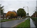
Broadwater Road A1000 Welwyn Garden City
Broadwater Road serves a mainly Industrial area of the Town. The famous (for its aroma) Wheat Processing plant is the tallest building, seen on the left of shot.
Image: © Richard Thomas
Taken: 14 Nov 2006
0.15 miles
10
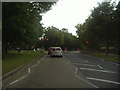
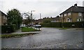
Traffic calming, Peartree Lane
Looking northwards.
Image: © Christine Johnstone
Taken: 1 Nov 2013
0.16 miles