IMAGES TAKEN NEAR TO
Fulling Mill Lane, WELWYN, AL6 9NH
Introduction
This page details the photographs taken nearby to Fulling Mill Lane, AL6 9NH by members of the Geograph project.
The Geograph project started in 2005 with the aim of publishing, organising and preserving representative images for every square kilometre of Great Britain, Ireland and the Isle of Man.

There are currently over 7.5m images from over14,400 individuals and you can help contribute to the project by visiting https://www.geograph.org.uk
Image Map
Images are licensed for reuse under creativecommons.org/licenses/by-sa/2.0
Notes
- Clicking on the map will re-center to the selected point.
- The higher the marker number, the further away the image location is from the centre of the postcode.
Image Listing (62 Images Found)
Images are licensed for reuse under creativecommons.org/licenses/by-sa/2.0
Image
Details
Distance
1

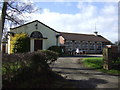
Welwyn Evangelical Church
Welwyn's fine looking Evangelical Church is located on Fulling Mill Lane a short distance from the village centre.
Image: © Stephen McKay
Taken: 12 Oct 2021
0.01 miles
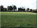
4
Cemetery and chapel
Taken from the Eastern side of Welwyn cemetery looking East, the horribly overexposed building with the short white steeple on its roof is the chapel on the OS map at TL228165
Image: © Rob Hinkley
Taken: 29 Apr 2006
0.03 miles
5

Fulling Mill Lane, Welwyn
Welwyn Evangelical Church is ahead on the left.
Image: © David Howard
Taken: 7 Aug 2022
0.04 miles
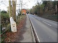
6

Kimpton Road
Heading west at the junction with Fulling Mill Lane.
Image: © JThomas
Taken: 22 Feb 2014
0.08 miles
7
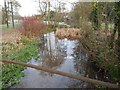
River Mimram in Welwyn
This is the view looking upstream as the river flows alongside the Singlers Marsh Local Nature Reserve.
All the old large scale Ordnance Survey maps available online, up to the edition of 1937, call the watercourse "The River Maran or Mimram".
Image: © Nigel Cox
Taken: 22 Nov 2015
0.09 miles
8
Welwyn: Listed milepost on the B656 Codicote Road
The milepost is a Grade II Listed Structure. The English Heritage website describes it thus:-
"Milepost. Mid C19. Cast iron. By Champness of Cheshunt. Triangular plan, hollow at back. 2 shallow panels with raised lettering: London 25 Hitchin 9. Sloping triangular top with semi-circular back panel."
The road is the B656 and once was the A600 between Welwyn and Hitchin.
The River Mimram is off to the left.
Image: © Nigel Cox
Taken: 22 Nov 2015
0.09 miles
9
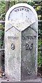
Old Milepost by the B656, Codicote Road, Welwyn
Cast iron post by the B656, in parish of WELWYN (WELWYN HATFIELD District), Codicote Road, North of Fulling Mill Lane, in pavement, back to railings, on West side of road. Cheshunt iron casting, erected by the Welwyn turnpike trust in the 19th century.
Inscription reads:-
: HITCHIN / 9 : : WELWYN : : LONDON / 25 :
Maker:-
: Champness of Cheshunt :
Grade II listed.
List Entry Number: 1100962 https://historicengland.org.uk/listing/the-list/list-entry/1100962
Milestone Society National ID: HE_LYX25a.
Image: © MW Hallett
Taken: 23 Mar 2003
0.09 miles
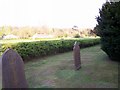
10

Welwyn Cemetery
Taken from near the Western boundary of the cemetery, looking roughly East.
Image: © Rob Hinkley
Taken: 29 Apr 2006
0.10 miles