IMAGES TAKEN NEAR TO
Ayot St. Lawrence, WELWYN, AL6 9BU
Introduction
This page details the photographs taken nearby to AL6 9BU by members of the Geograph project.
The Geograph project started in 2005 with the aim of publishing, organising and preserving representative images for every square kilometre of Great Britain, Ireland and the Isle of Man.

There are currently over 7.5m images from over14,400 individuals and you can help contribute to the project by visiting https://www.geograph.org.uk
Image Map (Loading...)


Getting Data...Please wait
Leaflet Map data © OpenStreetMap
Images are licensed for reuse under creativecommons.org/licenses/by-sa/2.0
Notes
- Clicking on the map will re-center to the selected point.
- The higher the marker number, the further away the image location is from the centre of the postcode.
Image Listing (144 Images Found)
Images are licensed for reuse under creativecommons.org/licenses/by-sa/2.0
Image
Details
Distance
2
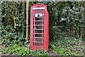
Ayot St. Lawrence: Public telephone in Hill Farm Lane
Image: © Michael Garlick
Taken: 22 Mar 2019
0.02 miles
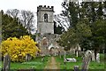
3

Ayot St Lawrence old church ruins in silhouette
Image: © Peter S
Taken: 1 Sep 2019
0.02 miles
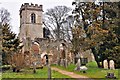
5
Ayot St. Lawrence: St. Lawrence's Church ruin
Image: © Michael Garlick
Taken: 22 Mar 2019
0.02 miles
6
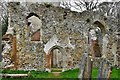
Ayot St. Lawrence, St. Lawrence's Old Church ruin: The south entrance
Image: © Michael Garlick
Taken: 22 Mar 2019
0.02 miles
7
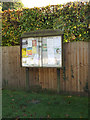
Ayot St. Lawrence Village Notice Board
On Hill Farm Lane
Image: © Geographer
Taken: 2 Nov 2016
0.02 miles
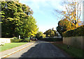
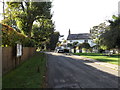
9
Ayot St. Lawrence: Hill Farm Lane
The War Memorial can just be seen.
Image: © Michael Garlick
Taken: 22 Mar 2019
0.02 miles