IMAGES TAKEN NEAR TO
West Riding, WELWYN, AL6 0PD
Introduction
This page details the photographs taken nearby to West Riding, AL6 0PD by members of the Geograph project.
The Geograph project started in 2005 with the aim of publishing, organising and preserving representative images for every square kilometre of Great Britain, Ireland and the Isle of Man.

There are currently over 7.5m images from over14,400 individuals and you can help contribute to the project by visiting https://www.geograph.org.uk
Image Map (Loading...)


Getting Data...Please wait
Leaflet Map data © OpenStreetMap
Images are licensed for reuse under creativecommons.org/licenses/by-sa/2.0
Notes
- Clicking on the map will re-center to the selected point.
- The higher the marker number, the further away the image location is from the centre of the postcode.
Image Listing (6 Images Found)
Images are licensed for reuse under creativecommons.org/licenses/by-sa/2.0
Image
Details
Distance
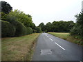
2
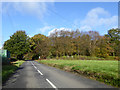
Orchard Road
From Tewin to Burnham Green.
Image: © Robin Webster
Taken: 5 Nov 2017
0.21 miles
4
Bus stop and shelter on Orchard Road, Burnham Green
Image: © JThomas
Taken: 3 Sep 2016
0.24 miles
5
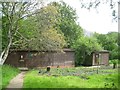
Tewin: Tewin Orchard Nature Reserve Hides
These are primarily mammal watching hides and the main hut on the left is The Audrey Randall Hide. The hides are open to the public at nighttime from April to mid-October, but the noticeboard stresses that access must be by prior appointment only as unbooked visitors could disturb the wildlife and spoil the enjoyment of those who have booked.
Image: © Nigel Cox
Taken: 20 May 2015
0.24 miles
6
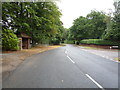
Orchard Road
Heading north west towards Burnham Green.
Image: © JThomas
Taken: 3 Sep 2016
0.24 miles