IMAGES TAKEN NEAR TO
Harmer Green Lane, WELWYN, AL6 0ES
Introduction
This page details the photographs taken nearby to Harmer Green Lane, AL6 0ES by members of the Geograph project.
The Geograph project started in 2005 with the aim of publishing, organising and preserving representative images for every square kilometre of Great Britain, Ireland and the Isle of Man.

There are currently over 7.5m images from over14,400 individuals and you can help contribute to the project by visiting https://www.geograph.org.uk
Image Map
Images are licensed for reuse under creativecommons.org/licenses/by-sa/2.0
Notes
- Clicking on the map will re-center to the selected point.
- The higher the marker number, the further away the image location is from the centre of the postcode.
Image Listing (16 Images Found)
Images are licensed for reuse under creativecommons.org/licenses/by-sa/2.0
Image
Details
Distance
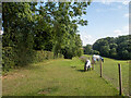
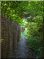
2
Footpath towards Digswell
Crossing a private drive.
Image: © Patrick Mackie
Taken: 3 Aug 2021
0.04 miles
4
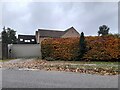
House on Harmer Green Lane, Burnham Green
Image: © David Howard
Taken: 14 Nov 2021
0.11 miles
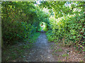
6
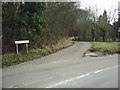
Pennyfathers Lane, Harmer Green
Pennyfathers Lane seen from its junction with Harmer Green Lane.
Image: © Rob Candlish
Taken: 13 Mar 2005
0.13 miles
7
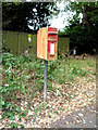
Elizabeth II postbox on Harmer Green Lane
Image: © JThomas
Taken: 3 Sep 2016
0.13 miles
8
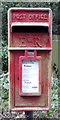
Close up, Elizabeth II postbox on Harmer Green Lane
Postbox No. AL6 156.
See Image] for wider view.
Image: © JThomas
Taken: 3 Sep 2016
0.13 miles
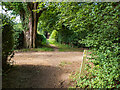
9
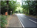
Harmer Green Lane
Showing position of Postbox No. AL6 156.
See Image] for postbox.
Image: © JThomas
Taken: 3 Sep 2016
0.13 miles