IMAGES TAKEN NEAR TO
Birch Way, HARPENDEN, AL5 5TP
Introduction
This page details the photographs taken nearby to Birch Way, AL5 5TP by members of the Geograph project.
The Geograph project started in 2005 with the aim of publishing, organising and preserving representative images for every square kilometre of Great Britain, Ireland and the Isle of Man.

There are currently over 7.5m images from over14,400 individuals and you can help contribute to the project by visiting https://www.geograph.org.uk
Image Map (Loading...)


Getting Data...Please wait
Leaflet Map data © OpenStreetMap
Images are licensed for reuse under creativecommons.org/licenses/by-sa/2.0
Notes
- Clicking on the map will re-center to the selected point.
- The higher the marker number, the further away the image location is from the centre of the postcode.
Image Listing (60 Images Found)
Images are licensed for reuse under creativecommons.org/licenses/by-sa/2.0
Image
Details
Distance
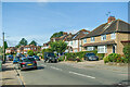
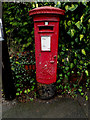
1
Piggottshill Lane, Harpenden
Postbox No.AL5 91D
Image: © Geographer
Taken: 16 Dec 2015
0.03 miles
2
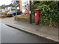
Piggottshill Lane George VI Postbox
On Piggottshill Lane
Postbox No.AL5 91D
Image: © Geographer
Taken: 16 Dec 2015
0.03 miles
3
Piggottshill Lane George VI Postbox
On Piggottshill Lane
Postbox No.AL5 91D
Image: © Geographer
Taken: 16 Dec 2015
0.03 miles
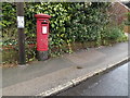
4
Piggottshill Lane George VI Postbox
On Piggottshill Lane
Postbox No.AL5 91D
(Close up)
Image: © Geographer
Taken: 16 Dec 2015
0.03 miles
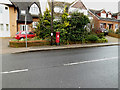
5
Piggottshill Lane & Piggottshill Lane George VI Postbox
Image: © Geographer
Taken: 16 Dec 2015
0.03 miles
6
Piggottshill Lane George VI Postbox
On Piggottshill Lane
Postbox No.AL5 91D
Image: © Geographer
Taken: 16 Dec 2015
0.03 miles
7
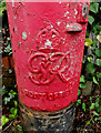
Royal Cypher on Piggottshill Lane George VI Postbox
On Piggottshill Lane
Postbox No.AL5 91D
Image: © Geographer
Taken: 16 Dec 2015
0.03 miles
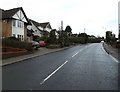
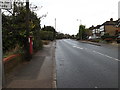
9
Piggottshill Lane, Harpenden
At the junction with Topstreet Way
Image: © Geographer
Taken: 16 Dec 2015
0.07 miles