IMAGES TAKEN NEAR TO
Sauncey Avenue, HARPENDEN, AL5 4QR
Introduction
This page details the photographs taken nearby to Sauncey Avenue, AL5 4QR by members of the Geograph project.
The Geograph project started in 2005 with the aim of publishing, organising and preserving representative images for every square kilometre of Great Britain, Ireland and the Isle of Man.

There are currently over 7.5m images from over14,400 individuals and you can help contribute to the project by visiting https://www.geograph.org.uk
Image Map
Images are licensed for reuse under creativecommons.org/licenses/by-sa/2.0
Notes
- Clicking on the map will re-center to the selected point.
- The higher the marker number, the further away the image location is from the centre of the postcode.
Image Listing (22 Images Found)
Images are licensed for reuse under creativecommons.org/licenses/by-sa/2.0
Image
Details
Distance
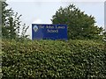
2
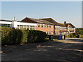
Sir John Lawes School
To older people more fondly remembered as Manland School
Image: © Gary Fellows
Taken: 10 Aug 2012
0.05 miles
4
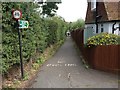
Public Footpath
From Cross Way to Wroxham Way
Image: © Gary Fellows
Taken: 7 Sep 2017
0.13 miles

8
Waveney Road
This road was built on the site of the old Harpenden East Railway Station which closed sometime late in the 1960s
Image: © Gary Fellows
Taken: 3 Oct 2008
0.22 miles
9
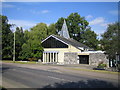
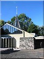
Harpenden: All Saints' Church
Located in Station Road, Batford, the church was completed in 1965, and its website is here http://www.stnicholasharpenden.co.uk/allsaints.html
Image: © Nigel Cox
Taken: 16 Sep 2007
0.22 miles
10
Church of the Holy Trinity in Station Rd Harpenden
I like the appearance of this church so deemed it worthwhile submitting it.
Image: © Jack Hill
Taken: 28 Aug 2005
0.22 miles