IMAGES TAKEN NEAR TO
Farm Avenue, HARPENDEN, AL5 3LY
Introduction
This page details the photographs taken nearby to Farm Avenue, AL5 3LY by members of the Geograph project.
The Geograph project started in 2005 with the aim of publishing, organising and preserving representative images for every square kilometre of Great Britain, Ireland and the Isle of Man.

There are currently over 7.5m images from over14,400 individuals and you can help contribute to the project by visiting https://www.geograph.org.uk
Image Map
Images are licensed for reuse under creativecommons.org/licenses/by-sa/2.0
Notes
- Clicking on the map will re-center to the selected point.
- The higher the marker number, the further away the image location is from the centre of the postcode.
Image Listing (14 Images Found)
Images are licensed for reuse under creativecommons.org/licenses/by-sa/2.0
Image
Details
Distance
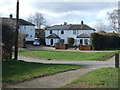
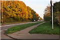
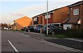
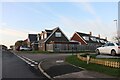
2
Houses on Farm Close, Kinsbourne Green
Image: © David Howard
Taken: 13 Nov 2022
0.04 miles
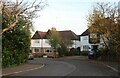
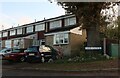
9
Crosspaths, Kinsbourne Green
Looking towards Shepherds Way. The first two houses on the left recently replaced a 1960s bungalow and its garden.
Image: © David Howard
Taken: 13 Nov 2022
0.24 miles
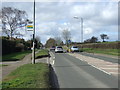
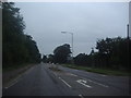
10
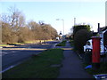
A1081 Luton Road & Kinsbourne Green Post Office George V Postbox
Looking towards Harpenden at Fiddler's Hill near Kinsbourne Green Post Office
Postbox No.AL5 46
Image: © Geographer
Taken: 9 Jan 2013
0.25 miles