IMAGES TAKEN NEAR TO
Moreton End Lane, HARPENDEN, AL5 2HA
Introduction
This page details the photographs taken nearby to Moreton End Lane, AL5 2HA by members of the Geograph project.
The Geograph project started in 2005 with the aim of publishing, organising and preserving representative images for every square kilometre of Great Britain, Ireland and the Isle of Man.

There are currently over 7.5m images from over14,400 individuals and you can help contribute to the project by visiting https://www.geograph.org.uk
Image Map
Images are licensed for reuse under creativecommons.org/licenses/by-sa/2.0
Notes
- Clicking on the map will re-center to the selected point.
- The higher the marker number, the further away the image location is from the centre of the postcode.
Image Listing (53 Images Found)
Images are licensed for reuse under creativecommons.org/licenses/by-sa/2.0
Image
Details
Distance
2
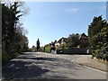
Park Hill, Harpenden
At the junction with Park Rise near The Nickey Line footpath
Image: © Geographer
Taken: 20 Apr 2016
0.02 miles
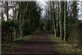
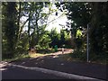
3
Nicky Line
Looking down the route of the old railway line
Image: © Gary Fellows
Taken: 3 Oct 2008
0.03 miles
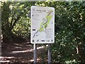
5
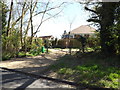
Level Access to The Nickey Line footpath
Off Park Hill
Image: © Geographer
Taken: 20 Apr 2016
0.05 miles
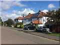
8

Bungalow on Moreton End Lane, Harpenden
Image: © David Howard
Taken: 25 Jul 2017
0.07 miles
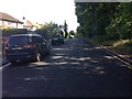
9
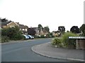
Alders End Lane at the junction of Claygate Avenue
Image: © David Howard
Taken: 25 Jul 2017
0.10 miles