IMAGES TAKEN NEAR TO
Moreton End Lane, HARPENDEN, AL5 2EX
Introduction
This page details the photographs taken nearby to Moreton End Lane, AL5 2EX by members of the Geograph project.
The Geograph project started in 2005 with the aim of publishing, organising and preserving representative images for every square kilometre of Great Britain, Ireland and the Isle of Man.

There are currently over 7.5m images from over14,400 individuals and you can help contribute to the project by visiting https://www.geograph.org.uk
Image Map
Images are licensed for reuse under creativecommons.org/licenses/by-sa/2.0
Notes
- Clicking on the map will re-center to the selected point.
- The higher the marker number, the further away the image location is from the centre of the postcode.
Image Listing (65 Images Found)
Images are licensed for reuse under creativecommons.org/licenses/by-sa/2.0
Image
Details
Distance
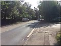
1
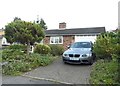
Bungalow on Moreton End Lane, Harpenden
Image: © David Howard
Taken: 25 Jul 2017
0.07 miles
2
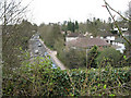
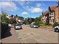
Harpenden from above
View along Luton Road (A1081) towards Harpenden town centre from the disused railway bridge. These seem to be leafy suburbs compared with the terraced housing on the other side of the line. In the foreground, nature is rapidly colonising the old trackbed either side of the cyclepath that the bridge now carries.
Image: © Martin Addison
Taken: 20 Apr 2006
0.08 miles
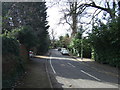
8
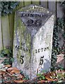
Old Milepost by the A1081, Luton Road, Harpenden
Cast iron post by the A1081, in parish of HARPENDEN (ST ALBANS District), Luton Road, opposite Moreton End Lane, in pavement, on East side of road. Luton iron casting, erected by the Luton District turnpike trust in the 19th century.
Inscription reads:-
: ST / ALBANS / 5 : : LONDON / 26 : : LUTON / 5 :
Maker:-
: Brown & Green Luton. :
Grade II listed. List Entry Number: 1103000
https://historicengland.org.uk/listing/the-list/list-entry/1103000
Milestone Society National ID: HE_LHX26.
Image: © MW Hallett
Taken: 30 Mar 2003
0.12 miles
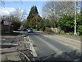
9
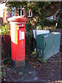
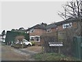
Douglas Road George V Postbox & Telecommunications Box
On the A1081 Luton Road at the junction with Douglas Road
Postbox No.AL5 2
Image: © Geographer
Taken: 9 Jan 2013
0.12 miles
10
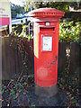
Douglas Road George V Postbox
On the A1081 Luton Road at the junction with Douglas Road
Postbox No.AL5 2
Image: © Geographer
Taken: 9 Jan 2013
0.12 miles