IMAGES TAKEN NEAR TO
Pipers Lane, HARPENDEN, AL5 1AQ
Introduction
This page details the photographs taken nearby to Pipers Lane, AL5 1AQ by members of the Geograph project.
The Geograph project started in 2005 with the aim of publishing, organising and preserving representative images for every square kilometre of Great Britain, Ireland and the Isle of Man.

There are currently over 7.5m images from over14,400 individuals and you can help contribute to the project by visiting https://www.geograph.org.uk
Image Map
Images are licensed for reuse under creativecommons.org/licenses/by-sa/2.0
Notes
- Clicking on the map will re-center to the selected point.
- The higher the marker number, the further away the image location is from the centre of the postcode.
Image Listing (3 Images Found)
Images are licensed for reuse under creativecommons.org/licenses/by-sa/2.0
Image
Details
Distance
1
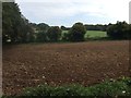
Farmland Ayres End
Ploughed farmland and fields off Ayres End Lane
Image: © Gary Fellows
Taken: 6 Sep 2017
0.13 miles
2
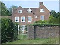
The Grove Harpenden
It looks like some form of rest home but I'm not too sure.
Image: © Jack Hill
Taken: 23 Aug 2005
0.23 miles
3

Pipers Lane Harpenden
Taken at junction with Ayres End Lane
Image: © Gary Fellows
Taken: 3 Feb 2008
0.23 miles