IMAGES TAKEN NEAR TO
Woodcock Hill, ST. ALBANS, AL4 9EB
Introduction
This page details the photographs taken nearby to Woodcock Hill, AL4 9EB by members of the Geograph project.
The Geograph project started in 2005 with the aim of publishing, organising and preserving representative images for every square kilometre of Great Britain, Ireland and the Isle of Man.

There are currently over 7.5m images from over14,400 individuals and you can help contribute to the project by visiting https://www.geograph.org.uk
Image Map (Loading...)


Getting Data...Please wait
Leaflet Map data © OpenStreetMap
Images are licensed for reuse under creativecommons.org/licenses/by-sa/2.0
Notes
- Clicking on the map will re-center to the selected point.
- The higher the marker number, the further away the image location is from the centre of the postcode.
Image Listing (6 Images Found)
Images are licensed for reuse under creativecommons.org/licenses/by-sa/2.0
Image
Details
Distance
1
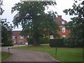
Fairshot Court in Woodcockhill Sandridge
The gates were shut and barred but with no fence alongside the gate posts.
Image: © Jack Hill
Taken: 19 Aug 2005
0.06 miles
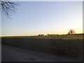
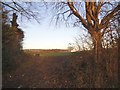
5
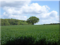
Hedgerow tree
Across a field of, probably, wheat.
Image: © Robin Webster
Taken: 14 May 2017
0.21 miles
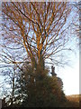
6
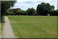
Footpath towards Woodcock Hill through recreation ground
Image: © Philip Jeffrey
Taken: 10 Jul 2013
0.25 miles